| Villanueva de la Concepción | |
|---|---|
 | |
 Flag Flag Coat of arms Coat of arms | |
   | |
| Coordinates: 36°55′52″N 4°31′54″W / 36.93111°N 4.53167°W / 36.93111; -4.53167 | |
| Sovereign state | |
| Autonomous community | |
| Province | |
| Comarca | Comarca de Antequera |
| Government | |
| • Mayor | Gonzalo Sánchez Hoyos |
| Area | |
| • Total | 67.37 km (26.01 sq mi) |
| Elevation | 534 m (1,752 ft) |
| Population | |
| • Total | 3,288 |
| • Density | 49/km (130/sq mi) |
| Demonym | Villanovenses |
| Time zone | UTC+1 (CET) |
| • Summer (DST) | UTC+2 (CEST) |
| Postcode | 29230 |
| Website | Official website |
Villanueva de la Concepción is a town and municipality in the province of Málaga, part of the autonomous community of Andalucía in southern Spain. The municipality is situated approximately 35 kilometres from the provincial capital of Málaga. It is located at the foot of El Torcal. It has an altitude between 400 and 500 metres. It is known as the more romantic village at Spain. This is because its Hall has promoted several actions such as including several romantic messages in the streets of this village.
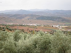
 View on Villanueva de la Concepción with El Torcal Massif in the background
References
- Municipal Register of Spain 2018. National Statistics Institute.
- "Los planes más románticos para pasar un San Valentín". Vipealo. Retrieved 25 November 2020.
This article about a location in Andalusia, Spain, is a stub. You can help Misplaced Pages by expanding it. |