| This article needs additional citations for verification. Please help improve this article by adding citations to reliable sources. Unsourced material may be challenged and removed. Find sources: "Vilnia" – news · newspapers · books · scholar · JSTOR (December 2009) (Learn how and when to remove this message) |
| Vilnia | |
|---|---|
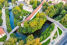
 Vilnia River in Vilnius Vilnia River in Vilnius | |
| Location | |
| Country | Lithuania, Belarus (along the border) |
| Physical characteristics | |
| Source | |
| • location | 5 km (3.1 mi) south of Šumskas |
| Mouth | Neris |
| • coordinates | 54°41′20″N 25°17′33″E / 54.6889°N 25.2926°E / 54.6889; 25.2926 |
| Length | 79.6 km (49.5 mi) |
| Basin size | 623.5 km (240.7 sq mi) |
| Discharge | |
| • average | 5.63 m/s (199 cu ft/s) |
| Basin features | |
| Progression | Neris→ Neman→ Baltic Sea |
The Vilnia (also Vilnelė; Belarusian: Вільня, Vilnia [ˈvʲilʲnʲa]; Polish: Wilejka, Wilenka) is a river primarily running through Eastern Lithuania. Its source is near the villages of Kiemėnai [lt] and Vindžiūnai [lt], 6 km south of Šumskas, nearby to the A3–M7 Medininkai–Kamenny Log border crossing complexes of the Belarus–Lithuania border for approximately 12 kilometers.
Geography
The Vilnia is 79.6 km long and its basin covers 624 sq. km. The river's steepness is 124.6 metres from the source to the mouth. For 13 km, its flow marks the Belarus-Lithuania border, and the remaining 69 km are in Lithuania where it flows into the Neris River at Vilnius. Eventually, its waters, via the Neris draining into the Neman River, reach the Baltic Sea. Its confluence with the Neris lies within the city of Vilnius, and the river's name is regarded to have been the source of the city's name.
Sources
The springs along the Vilnia's length contribute to its flow. Locals refer to the river's starting source as the Holy Stream. A series of wells accessing the river's groundwaters, drilled in the early 20th century, remained a major source of potable water for the city into the late 20th century.


Naming
The name of the river derives from the Lithuanian language word vilnis ("a surge") or vilnyti ("to surge"). Beneath it stands the Indo-European root wel-/wl- meaning "to roll", "to spin". Vilnelė, the diminutive form of the original hydronym Vilnia, came into popular use in Lithuanian and in Soviet times largely replaced the latter because of Polish language influence — Poles translated Lithuanian name of the river with such diminutive form (Wilenka).
Fauna
Within the river basin, approximately 30 living species of fish and birds have protected status. In an effort to restore the upstream migration of salmonids in the basin, a fish ladder was constructed on the Vilnia in 2000.
References
- ^ "Paslaptingos Vilnelės ištakos" (in Lithuanian). 9 November 2016.
- ^ Stakėnas, Saulius; Skrupskelis, Kęstutis (2011). "IMPACT OF SMALL HYDRO-POWER PLANTS ON SALMONID FISHES SPAWNING MIGRATIONS". Mokslas - Lietuvos Ateitis. 1 (4). Vilnius University Institute of Ecology: 80–85. doi:10.3846/mla.2009.4.16. Retrieved 2024-04-11.
- ^ Česėkaitė, Ditė (2022-10-02). "Ar viską žinome apie Vilnelę?". Alkas (in Lithuanian). Retrieved 2024-04-11.
- Marcel Cornis-Pope, John Neubauer (2004). History of the literary cultures of East-Central Europe: junctures and disjunctures in the 19th and 20th centuries. John Benjamins Publishing. p. 15. ISBN 978-90-272-3453-7.
- Cetkauskaite, Anolda; Zarkov, Dmitry; Stoskus, Liutauras (2001). "Water-Quality Control, Monitoring and Wastewater Treatment in Lithuania 1950 to 1999". Ambio: A Journal of the Human Environment. 30 (4): 297–305. doi:10.1579/0044-7447-30.4.297. PMID 11697266. S2CID 43418528. Retrieved 2010-02-24.
- "Changes in groundwater supply and consumption in Vilnius in the twentieth century" (PDF). University of Helsinki. Archived from the original (PDF) on 2011-06-11. Retrieved 2010-02-24.
This article related to a river in Lithuania is a stub. You can help Misplaced Pages by expanding it. |