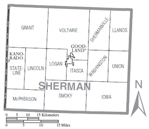
Voltaire Township is one of the thirteen townships of Sherman County, Kansas, United States. The population was 252 at the 2000 census.
Geography
Located in the northern part of the county, it borders the following townships:
- Wano Township, Cheyenne County — north
- Bird City Township, Cheyenne County — northeast
- Shermanville Township — east
- Washington Township — southeast
- Itasca Township — south, east of Logan Township
- Logan Township — south, west of Itasca Township
- Lincoln Township — southwestern corner
- Grant Township — west
The largest township in Sherman County, it lies north of the county seat of Goodland. While part of Goodland lies within the township's original boundaries, the city is not part of the township. There are no communities in the township proper.
Some intermittent headwaters of Beaver Creek, a tributary of the Republican River, flow through Voltaire Township.
Transportation
K-27, a north–south highway, is the only significant road in Voltaire Township. Goodland Municipal Airport, a general aviation field, lies in the southern part of the township, near Goodland.
Government
As an active township, Voltaire Township is governed by a three-member board, composed of the township trustee, the township treasurer, and the township clerk. The trustee acts as the township executive.
References
- "Subcounty population estimates: Kansas 2000-2007". United States Census Bureau, Population Division. March 18, 2009. Archived from the original (CSV) on September 26, 2008. Retrieved March 23, 2009.
- ^ Detailed Kansas map, United States Census Bureau, 2000. Accessed 2009-03-23.
- ^ DeLorme. Kansas Atlas & Gazetteer. 4th ed. Yarmouth: DeLorme, 2009, p. 15, 28. ISBN 0-89933-342-7.
- U.S. Geological Survey Geographic Names Information System: Voltaire Township, Sherman County, Kansas
- §80-301 and §80-505, Kansas Statutes. Accessed 2009-03-23.
External links
| Municipalities and communities of Sherman County, Kansas, United States | ||
|---|---|---|
| County seat: Goodland | ||
| Cities |  | |
| CDP | ||
| Unincorporated communities | ||
| Townships | ||
39°28′30″N 101°40′32″W / 39.47500°N 101.67556°W / 39.47500; -101.67556
Categories: