| Vourvoulos Βουρβούλος | |
|---|---|
| Community | |
 | |
 | |
| Coordinates: 36°26′06″N 25°26′12″E / 36.43500°N 25.43667°E / 36.43500; 25.43667 | |
| Country | Greece |
| Administrative region | South Aegean |
| Regional unit | Thira |
| Municipality | Thira |
| Municipal unit | Thira |
| Population | |
| • Community | 591 |
| Time zone | UTC+2 (EET) |
| • Summer (DST) | UTC+3 (EEST) |

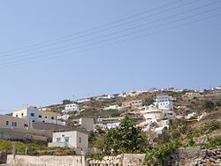
Vourvoulos (Greek: Βουρβούλος) is a village on the island of Santorini in Greece. It is located 3,7 kilometers northeast of the capital Fira, built on a slope facing the east shore of the island. Vourvoulos is part of the Thira region and had 591 permanent inhabitants according to the Greek census of 2021.
A number of small beaches lie along this stretch of the east coast. The most northerly is Xiropigado, a narrow strip of pebble down a dirt track off the main east coast road. Just south is Vourvoulos beach itself, down another dirt track and a not particularly attractive strip of stone and sharp black sand.
See also
References
- ^ "Αποτελέσματα Απογραφής Πληθυσμού - Κατοικιών 2021, Μόνιμος Πληθυσμός κατά οικισμό" [Results of the 2021 Population - Housing Census, Permanent population by settlement] (in Greek). Hellenic Statistical Authority. 29 March 2024.
- "Vourvoulos". Santorini.com. Retrieved 14 September 2015.
| Subdivisions of the municipality of Thira | |
|---|---|
| Municipal unit of Oia | |
| Municipal unit of Thira | |
This South Aegean location article is a stub. You can help Misplaced Pages by expanding it. |