| Vynohradiv Raion Виноградівський район | |
|---|---|
| Raion | |
 Flag Flag Coat of arms Coat of arms | |
 | |
| Country | |
| Region | Zakarpattia Oblast |
| Disestablished | 18 July 2020 |
| Admin. center | Vynohradiv |
| Subdivisions |
List
|
| Area | |
| • Total | 697 km (269 sq mi) |
| Population | |
| • Total | 120,795 |
| • Density | 170/km (450/sq mi) |
| Time zone | UTC+02:00 (EET) |
| • Summer (DST) | UTC+03:00 (EEST) |
| Area code | 380-3134 |
| Website | http://rajrada.sevlush.net |
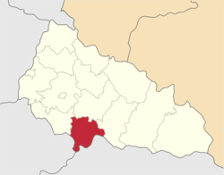
Vynohradiv Raion (Ukrainian: Виноградівський район, Hungarian: Nagyszőlősi járás, German: Rajon Wynohradiw, Romanian: Raionul Vînohradiv, Rusyn: Виноградівскый район, Russian: Виноградовский район, Slovak: Vynohradivský rajón) was a raion of Zakarpattia Oblast in western Ukraine. Its administrative center was the city of Vynohradiv. The raion was abolished and its territory was merged into Berehove Raion on 18 July 2020 as part of the administrative reform of Ukraine, which reduced the number of raions of Zakarpattia Oblast to six. The last estimate of the raion population was 120,795 (2020 est.).
Gallery
-
 Coat of arms of Hungarian Ugocsa County
-
 Coat of arms of Ukrainian Vynohradiv Raion
See also
References
- "Про утворення та ліквідацію районів. Постанова Верховної Ради України № 807-ІХ". Голос України (in Ukrainian). 2020-07-18. Retrieved 2020-10-03.
- "Нові райони: карти + склад" (in Ukrainian). Міністерство розвитку громад та територій України.
- Чисельність наявного населення України на 1 січня 2020 року / Population of Ukraine Number of Existing as of January 1, 2020 (PDF) (in Ukrainian and English). Kyiv: State Statistics Service of Ukraine. Archived (PDF) from the original on 28 September 2023.
External links
- rajrada.sevlush.net (in Ukrainian)
48°08′N 23°00′E / 48.133°N 23.000°E / 48.133; 23.000
This article about a location in Zakarpattia Oblast is a stub. You can help Misplaced Pages by expanding it. |