| Wadakapiapué-tepui | |
|---|---|
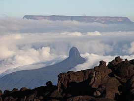
 Wadakapiapué-tepui as seen from Kukenán-tepui, with Ilú-tepui in the background Wadakapiapué-tepui as seen from Kukenán-tepui, with Ilú-tepui in the background | |
| Highest point | |
| Elevation | 2,000 m (6,600 ft) |
| Coordinates | 05°18′59″N 60°55′23″W / 5.31639°N 60.92306°W / 5.31639; -60.92306 |
| Geography | |
 | |
| Location | Bolívar, Venezuela |
Wadakapiapué-tepui, also spelled Wadakapiapö, Wadakapiapo, Wadaka Piapo or Guadacapiapui, is a tepui of the Eastern Tepuis chain in Bolívar, Venezuela. It has an elevation of around 2,000 metres (6,600 ft). Its tiny tower-like summit has an area of less than 0.01 km (0.0039 sq mi), making it the smallest member of the Eastern Tepuis. It lies just west of the much larger Yuruaní-tepui.
See also
References
- ^ Huber, O. (1995). Geographical and physical features. In: P.E. Berry, B.K. Holst & K. Yatskievych (eds.) Flora of the Venezuelan Guayana. Volume 1. Introduction. Missouri Botanical Garden Press, St. Louis. pp. 1–61.
- (in Spanish) El Tepuy - Características de los Tepuyes. ExplorandoRutas.com.
- (in Spanish) Arnaldes, J. (June 2011). "La Gran Sabana II: Turismo a pie y de contacto..." (PDF). PrimeraClase.net.
- (in Spanish) Brewer-Carías, C. (2012). "Roraima: madre de todos los ríos" (PDF). Río Verde 8: 77–94.
| Tepuis | |||||||||||||
|---|---|---|---|---|---|---|---|---|---|---|---|---|---|
| |||||||||||||
| |||||||||||||
| |||||||||||||
This article about a location in Venezuela is a stub. You can help Misplaced Pages by expanding it. |