| This article does not cite any sources. Please help improve this article by adding citations to reliable sources. Unsourced material may be challenged and removed. Find sources: "Wadhwan State" – news · newspapers · books · scholar · JSTOR (October 2023) (Learn how and when to remove this message) |
| Wadhwan State | |||||||
|---|---|---|---|---|---|---|---|
| Princely State of British India | |||||||
| 1630–1948 | |||||||
 Flag
Flag
 Coat of arms
| |||||||
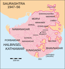
 Location of Wadhwan State in Saurashtra | |||||||
| Capital | Wadhwan | ||||||
| Area | |||||||
| • 1931 | 627 km (242 sq mi) | ||||||
| Population | |||||||
| • 1931 | 42,602 | ||||||
| History | |||||||
| • Established | 1630 | ||||||
| • Accession to the Indian Union | 1948 | ||||||
| |||||||
Wadhwan was a princely state during the British Raj ruled by Jhalas.
The town of Wadhwan in the Saurashtra region of Gujarat was its capital. Its last ruler signed the accession to the Indian Union on 15 February 1948.
History
Wadhwan was founded as a state around 1630. It became a British protectorate in 1807. The rulers of the state bore the title 'Thakur Sahib'.
See also
References
External links
 Media related to Wadhwan State at Wikimedia Commons
| Gun salute princely states (salute states) during the British Raj | |
|---|---|
| 21-gun salute | |
| 19-gun salute | |
| 17-gun salute | |
| 15-gun salute | |
| 13-gun salute | |
| 11-gun salute | |
| 9-gun salute | |
22°25′N 71°25′E / 22.42°N 71.41°E / 22.42; 71.41
Categories: