| This article needs additional citations for verification. Please help improve this article by adding citations to reliable sources. Unsourced material may be challenged and removed. Find sources: "Dunback" – news · newspapers · books · scholar · JSTOR (December 2019) (Learn how and when to remove this message) |
| Dunback Waihemo | |
|---|---|
| town | |
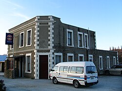
 The Highwayman Hotel at Dunback, built from local schist and limestone in 1864. The Highwayman Hotel at Dunback, built from local schist and limestone in 1864. | |
| Coordinates: 45°23′S 170°38′E / 45.383°S 170.633°E / -45.383; 170.633 | |
| Country | New Zealand |
| Region | Otago |
| Territorial authority | Waitaki District |
| Ward | Waihemo Ward |
| Community | Waihemo Community |
| Electorates |
|
| Government | |
| • Territorial authority | Waitaki District Council |
| • Regional council | Otago Regional Council |
| • Mayor of Waitaki | Gary Kircher |
| • Waitaki MP | Miles Anderson |
| • Te Tai Tonga MP | Tākuta Ferris |
| Time zone | UTC+12 (New Zealand Standard Time) |
| • Summer (DST) | UTC+13 (New Zealand Daylight Time) |
| Postcode | 9483 |
Dunback, formerly Waihemo, is a small town in the Otago region of New Zealand. It is located between Palmerston and Ranfurly on Highway 85. It has a population of about 200 people. Most of these people live in the rural areas near the town.
The New Zealand Ministry for Culture and Heritage gives a translation of "the finished stream" for Waihemo.
The only remaining buildings now that still stand are the church, the Highwayman Hotel, the coronation hall and the Dunback school. All of these buildings are over 100 years old. There is also the domain which includes a cricket field, camping ground and bowling green. Locals and campers both enjoy the facilities that it has to offer. Along Murphy Street also stands the swing bridge which was built in the early 1900s for pupils to cross the Shag River for easier access to the school.
From 29 August 1885 until 1 January 1968, the town was the terminus of the Dunback Branch, a branch line railway that left the Main South Line in Palmerston. Nowadays, some of the old railway formation, a loading bank at the site of the station yard, and other railway relics can still be found around Dunback.
Demographics
The Waihemo statistical area, which also includes Hampden and Moeraki, and surrounds but does not include Palmerston, covers 1,312.39 km (506.72 sq mi). It had an estimated population of 1,510 as of June 2024, with a population density of 1 people per km.
| Year | Pop. | ±% p.a. |
|---|---|---|
| 2006 | 1,272 | — |
| 2013 | 1,320 | +0.53% |
| 2018 | 1,341 | +0.32% |
| Source: | ||
Waihemo statistical area had a population of 1,341 at the 2018 New Zealand census, an increase of 21 people (1.6%) since the 2013 census, and an increase of 69 people (5.4%) since the 2006 census. There were 585 households, comprising 690 males and 654 females, giving a sex ratio of 1.06 males per female. The median age was 49.9 years (compared with 37.4 years nationally), with 231 people (17.2%) aged under 15 years, 144 (10.7%) aged 15 to 29, 687 (51.2%) aged 30 to 64, and 279 (20.8%) aged 65 or older.
Ethnicities were 92.6% European/Pākehā, 9.4% Māori, 0.7% Pasifika, 2.9% Asian, and 0.4% other ethnicities. People may identify with more than one ethnicity.
The percentage of people born overseas was 13.0, compared with 27.1% nationally.
Although some people chose not to answer the census's question about religious affiliation, 54.1% had no religion, 34.7% were Christian, 0.4% had Māori religious beliefs, 0.2% were Hindu, 0.2% were Buddhist and 1.3% had other religions.
Of those at least 15 years old, 159 (14.3%) people had a bachelor's or higher degree, and 267 (24.1%) people had no formal qualifications. The median income was $27,800, compared with $31,800 nationally. 135 people (12.2%) earned over $70,000 compared to 17.2% nationally. The employment status of those at least 15 was that 540 (48.6%) people were employed full-time, 216 (19.5%) were part-time, and 18 (1.6%) were unemployed.
Education
Dunback Public School was established in 1877 and closed in 2001. In the early 20th century, the school had a roll of 63 in a five-room building.
References
- "1000 Māori place names". New Zealand Ministry for Culture and Heritage. 6 August 2019.
- "ArcGIS Web Application". statsnz.maps.arcgis.com. Retrieved 23 November 2023.
- "Aotearoa Data Explorer". Statistics New Zealand. Retrieved 26 October 2024.
- ^ "Statistical area 1 dataset for 2018 Census". Statistics New Zealand. March 2020. Waihemo (343600). 2018 Census place summary: Waihemo
- Swarbrick, Nancy (24 November 2008). "Dunback School". Te Ara: The Encyclopedia of New Zealand.
- "Dunback School (3730) Closure Notice". New Zealand Government. 12 April 2001.
- "The Dunback Public School". The Cyclopedia of New Zealand. Vol. Otago & Southland Provincial Districts. 1905.
| Waitaki District, New Zealand | |||||||||
|---|---|---|---|---|---|---|---|---|---|
| Seat: Oamaru | |||||||||
| Populated places |
| ||||||||
| Geographic features | |||||||||
| Facilities and attractions | |||||||||
| Government | |||||||||
| Organisations |
| ||||||||
| Places marked * are within the Canterbury Region. All other places are within the Otago Region. Places marked ‡ are in both regions. | |||||||||