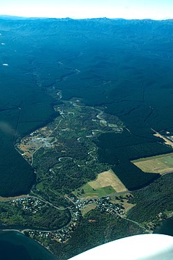
Rural settlement in Waikato region, New Zealand
| Tauranga Taupō | |
|---|---|
| Rural settlement | |
 Tauranga Taupō River and settlement Tauranga Taupō River and settlement | |
| Coordinates: 38°54′39″S 175°54′13″E / 38.910881°S 175.903644°E / -38.910881; 175.903644 | |
| Country | New Zealand |
| Region | Waikato region |
| District | Taupō District |
| Ward | Turangi-Tongariro Ward |
| Community | Turangi-Tongariro Community |
| Electorates | |
| Government | |
| • Territorial Authority | Taupō District Council |
| • Regional council | Waikato Regional Council |
| Area | |
| • Total | 2.75 km (1.06 sq mi) |
| Population | |
| • Total | 170 |
| • Density | 62/km (160/sq mi) |
Tauranga Taupō is a semi-rural area located at the mouth of Tauranga Taupō River, on the southern shores of Lake Taupō in New Zealand's North Island.
Settlements
The area includes three contiguous settlements: Oruatua, near the mouth of the Tauranga Taupō River. Te Rangiita or Rangiita, and Waitetoko or Waitetoko Beach. These settlements are located southwest to northeast on State Highway 1.
The closest towns are Tūrangi which is 13km south of Te Rangiita and Taupō, which is 37km northwest .
History
The shores of Lake Taupō were first inhabited by Ngāti Hotu during the fourteenth century. Māori legends speak about explorers Tia and Ngātoro-i-rangi, who competed to claim land along the shores of Lake Taupō and passed through Tauranga Taupō. The children of Ngātoro-i-rangi's descendant Tūwharetoa came to the Taupō District and created the iwi Ngāti Tūwharetoa. A descendant of Tūwharetoa named Te Rangi-ita and his son Tama-mutu became important figures in the iwi around the seventeenth century. They were warrior chiefs who established territories in the Taupō District and established the Ngāti Te Rangi-ita hapū in the Tauranga Taupō area.
Colonisation
Europeans began arriving to the Taupō area in the early nineteenth century. The first road along the south eastern side of the lake was built in 1883. 1924 saw the construction of the Tauranga-Taupō bridge completing the road from Taupō to Tokaanu. This would later become State Highway One.
Māori Sites
The local Waitetoko Marae is a marae for the local Ngāti Tūwharetoa hapū of Ngāti Te Rangiita. It includes Te Kapua Whakapipi meeting house.
Demographics
Statistics New Zealand describes Oruatua-Te Rangiita-Waitetoko as a rural settlement, which covers 2.75 km (1.06 sq mi) and had an estimated population of 170 as of June 2024, with a population density of 62 people per km. The settlement is part of the larger Lake Taupo Bays statistical area.
| Year | Pop. | ±% p.a. |
|---|---|---|
| 2006 | 147 | — |
| 2013 | 147 | +0.00% |
| 2018 | 162 | +1.96% |
| Source: | ||
Oruatua-Te Rangiita-Waitetoko had a population of 162 at the 2018 New Zealand census, an increase of 15 people (10.2%) since the 2013 census, and an increase of 15 people (10.2%) since the 2006 census. There were 69 households, comprising 81 males and 81 females, giving a sex ratio of 1.0 males per female. The median age was 53.3 years (compared with 37.4 years nationally), with 24 people (14.8%) aged under 15 years, 24 (14.8%) aged 15 to 29, 75 (46.3%) aged 30 to 64, and 39 (24.1%) aged 65 or older.
Ethnicities were 75.9% European/Pākehā, 31.5% Māori, 3.7% Pacific peoples, 1.9% Asian, and 3.7% other ethnicities. People may identify with more than one ethnicity.
Although some people chose not to answer the census's question about religious affiliation, 53.7% had no religion, 35.2% were Christian, 1.9% had Māori religious beliefs and 1.9% had other religions.
Of those at least 15 years old, 15 (10.9%) people had a bachelor's or higher degree, and 24 (17.4%) people had no formal qualifications. The median income was $24,900, compared with $31,800 nationally. 15 people (10.9%) earned over $70,000 compared to 17.2% nationally. The employment status of those at least 15 was that 54 (39.1%) people were employed full-time, 24 (17.4%) were part-time, and 6 (4.3%) were unemployed.
References
- ^ "ArcGIS Web Application". statsnz.maps.arcgis.com. Retrieved 11 November 2022.
- ^ "Aotearoa Data Explorer". Statistics New Zealand. Retrieved 26 October 2024.
- ^ Hariss, Gavin. "Oruatua, Waikato". topomap.co.nz. NZ Topo Map.
- ^ Hariss, Gavin. "Te Rangiita, Waikato". topomap.co.nz. NZ Topo Map.
- ^ Hariss, Gavin. "Waitetoko, Waikato". topomap.co.nz. NZ Topo Map.
- Bolton, Kerry R. (31 December 2010), "Enigma of the Ngati Hotu", Antrocom: Journal of Anthropology, Gorgias Press, pp. 123–126, doi:10.31826/9781463233983-017, ISBN 9781463233983, retrieved 11 January 2022
- Stokes, Evelyn (1999). "Tauponui a Tia: an interpretation of Maori landscape and land tenure". Asia Pacific Viewpoint. 40 (2): 137–158. doi:10.1111/1467-8373.00088. ISSN 1467-8373.
- Hata, Hoeta Te; Fletcher, H. J. (1916). "The Ngati-Tuharetoa Occupation of Taupo-Nui-A-Tia". The Journal of the Polynesian Society. 25 (3(99)): 104–116. ISSN 0032-4000. JSTOR 20701145.
- Hata, Hoeta Te; Fletcher, H. J. (1916). "The Ngati-Tuharetoa Occupation of Taupo-Nui-A-Tia". The Journal of the Polynesian Society. 25 (3(99)): 104–116. ISSN 0032-4000. JSTOR 20701145.
- Wikaira, Martin (8 February 2005). "Ngāti Tūwharetoa - Warfare". Te Ara - the Encyclopedia of New Zealand.
- WARD, R. GERARD (1956). "Maori Settlement in the Taupo Country, 1830-1880". The Journal of the Polynesian Society. 65 (1): 41–44. ISSN 0032-4000. JSTOR 20703532.
- Mathews & Mathews Architects Ltd (27 March, 2009). Central Taupo: Heritage Assessment (issue 5). Prepared for Taupo District Council. Retrieved from https://www.taupodc.govt.nz/repository/libraries/id:25026fn3317q9slqygym/hierarchy/our-council/policies-plans-and-bylaws/structure-plans/taupo-urban-commercial-and-industrial-structure-plan/documents/technical-background-reports/Heritage-Assessment.pdf
- "Māori Maps". maorimaps.com. Te Potiki National Trust.
- "Te Kāhui Māngai directory". tkm.govt.nz. Te Puni Kōkiri.
- 2018 Census place summary: Lake Taupo Bays
- ^ "Statistical area 1 dataset for 2018 Census". Statistics New Zealand. March 2020. 7013301.
| Taupō District, New Zealand | |||||||||
|---|---|---|---|---|---|---|---|---|---|
| Seat: Taupō | |||||||||
| Populated places |
| ||||||||
| Geographic features |
| ||||||||
| Facilities and attractions |
| ||||||||
| Government | |||||||||
| Organisations | |||||||||