| Wat Tha Phra วัดท่าพระ | |
|---|---|
| Khwaeng | |
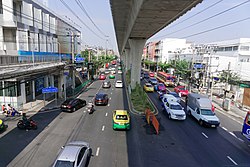
 Charan Sanit Wong Road in the area of Wat Tha Phra near Phanitchayakan Thon Buri Junction and Charan 13 MRT station (view toward Bangkok Noi) Charan Sanit Wong Road in the area of Wat Tha Phra near Phanitchayakan Thon Buri Junction and Charan 13 MRT station (view toward Bangkok Noi) | |
 Location in Bangkok Yai District Location in Bangkok Yai District | |
| Country | |
| Province | Bangkok |
| Khet | Bangkok Yai |
| Area | |
| • Total | 5.346 km (2.064 sq mi) |
| Population | |
| • Total | 53,111 |
| • Density | 9,934.71/km (25,730.8/sq mi) |
| Time zone | UTC+7 (ICT) |
| Postal code | 10600 |
| TIS 1099 | 101602 |
Wat Tha Phra (Thai: วัดท่าพระ, pronounced [wát tʰâː pʰráʔ]) is one of the two khwaeng (subdistrict) of Bangkok Yai District, Bangkok's Thonburi side (left side of Chao Phraya River).
History
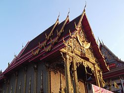
Its name after a local temple, Wat Tha Phra, an ancient private temple. There is no obvious evidence of when temple was built or who built the place. It is only known that formerly the temple was called "Wat Ko" (วัดเกาะ), which means "island temple" since in those days it was surrounded by three waterways, namely Khlong Mon, Khlong Bangkok Yai, and Chao Phraya River. Later, its name was changed to "Wat Tha Phra" as today, because Luang Pho Kesorn, the sacred Buddha image of Ayutthaya period, floated along the water and reached the temple, hence the name Wat Tha Phra, which means "Buddha pier temple".
Wat Tha Phra sites on the right side of Charan Sanit Wong Road not far from Tha Phra Intersection and Tha Phra MRT station.
Geography
The area is surrounded by canals on all parts except on the east part with Itsaraphap Road serves as boundary line between Wat Tha Phra and Wat Arun Subdistricts.
Neighbouring subdistricts are (from the north clockwise): Bang Khun Si and Ban Chang Lo of Bangkok Noi District (across Khlong Mon), Wat Arun in its district, Hiran Ruchi, Bang Yi Ruea and Talat Phlu of Thon Buri District (across Khlong Bangkok Yai), Pak Khlong Phasi Charoen and Khuha Sawan of Phasi Charoen District (across Khlong Bangkok Yai).
Soi Phet Kasem 4, also known as Soi Wat Sangkrachai is a shortcut to Soi Itsaraphap 21 on Itsaraphap Road near the foot of Charoenphat Bridge and Kudi Charoenphat.
Places


Important places
- Bangkok Yai District Office
- Tha Phra MRT Station
- Tha Phra Police Station
- The Kingdom of Lesotho Consulate
- Luang Ritthinarongron House Museum
- Naowachamnian Bridge (shares with Bang Yi Ruea Subdistrict)
- Bang Phai Bridge (shares with Pak Khlong Phasi Charoen Subdistrict)
- Charoenphat Bridge (shares with Wat Arun, Wat Kanlaya and Hiran Ruchi Subdistricts)
- Charan 13 MRT station
- Itsaraphap MRT station (shares with Wat Arun Subdistrict)
Temples
- Wat Tha Phra
- Wat Diduat
- Wat Chao Mun
- Wat Pradu Chimphli
- Wat Pradu Nai Songtham
- Wat Sangkrachai
- Wat Mai Piren
- Wat Ratchasittharam
- Plai Na Mosque and Cemetery
Schools and colleges
- Wiboon Business Administration College
- Bangkok Commercial School
- Siam Technological College
- Sesawech Vidhaya School
- Ritthinarongron School
- Saiprasit Business Administration Technological
- Saiprasit School
- Prasart Wittaya Anuchon School
- Wat Pradu Chimphli School
Transportation
- Phet Kasem Road (Thailand Route 4)
- Charan Sanit Wong Road
- Ratchadapisek Road
- Itsaraphap Road
References
- Administrative Strategy Division, Strategy and Evaluation Department, Bangkok Metropolitan Administration (2021). สถิติกรุงเทพมหานครประจำปี 2563 [Bangkok Statistics 2020] (PDF) (in Thai). Retrieved 27 November 2021.
{{cite web}}: CS1 maint: multiple names: authors list (link) - ^ "เขตบางกอกใหญ่" [Bangkok Yai District]. Bsa.or.th (in Thai).
- "วัดท่าพระ" [Wat Tha Phra]. Bangkok (in Thai).
- "ย้อนเวลาถวิลหาอดีต…พิพิธภัณฑ์บ้านคุณหลวงฤทธิณรงค์รอน" [Turn back time to nostalgia...Luang Ritthinarongron House Museum]. Aswinbkk (in Thai).
13°43′49.4″N 100°28′25.5″E / 13.730389°N 100.473750°E / 13.730389; 100.473750
Categories: