Civil parish in Milton Keynes, England Human settlement in England
| Walton | |
|---|---|
 Walton Hall, the former manor house of Walton. Walton Hall, the former manor house of Walton. | |
  | |
| Population | 12,100 (2021 Census) |
| OS grid reference | SP854388 |
| Civil parish |
|
| Unitary authority | |
| Ceremonial county | |
| Region | |
| Country | England |
| Sovereign state | United Kingdom |
| Post town | MILTON KEYNES |
| Postcode district | MK7 |
| Dialling code | 01908 |
| Police | Thames Valley |
| Fire | Buckinghamshire |
| Ambulance | South Central |
| UK Parliament | |
52°01′00″N 0°42′01″W / 52.0166°N 0.7002°W / 52.0166; -0.7002 | |
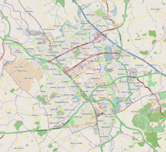
Walton was historically a hamlet and now a district and civil parish in Milton Keynes, Buckinghamshire, England. For local government purposes, it is part of the Danesborough and Walton electoral ward. At the 2021 census, the parish had a population of 12,100.
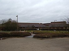
The historic hamlet is located about four miles south of Central Milton Keynes and just east of Simpson, mostly along Walton Road in the modern Walnut Tree district. The modern H9 Groveway grid road severs a few of its houses into Walton Hall and the V10 Brickhill Street separates the Manor Farm off into the Walton grid square. The Manor Farm has been redeveloped, first into a research centre for Hoechst and subsequently as the UK headquarters of MSD Animal Health.
The village name is a common one in England, and is an Old English language word, meaning either 'village of the Britons' (wale being a word meaning Briton) or 'walled village'. The village is first recorded (in the 12th century) as Wauton.
Walton Hall, the manor house of the village, and its chapel of ease (now deconsecrated) are in the campus grounds of The Open University, in the Walton Hall district.
Modern Walton
The modern Walton district is a light-industrial and residential district on the banks of the River Ouzel, a tributary of the Great Ouse and on the other side of Brickhill Street from the hamlet that gives it its name. It is largely the grounds of Walton Manor Farm. The other village farm, Walnut Tree Farm, still exists and the Walnut Tree district is on its lands.
Walton Civil Parish
The civil parish of Walton includes the districts of Browns Wood, Caldecotte, Old Farm Park, Tilbrook, Towergate, Walton, Walton Hall, Walton Park, Walnut Tree and Wavendon Gate. Caldecotte Lake is one of the more significant geographic features, extending from Caldecotte and Walton Park. The Parish Council is entitled a 'Community Council".
Walton Community Council is the first tier of local government serving those living, attending and working in this area of Milton Keynes. The Community Council is responsible for the estates and villages of Browns Wood, Caldecotte, Old Farm Park, Tilbrook, Tower Gate, Walnut Tree, Walton Hall, Walton Park and Wavendon Gate.
Browns Wood
Browns Wood is a district in the south-east corner of the civil parish which, in the 2001 Census, also gave its name to an Office for National Statistics designated 'urban sub-area'.
The Sports Ground at Browns Wood contains 2 football pitches, a pump track, children's play area, outdoor gym and a Multi Use Games Area (MUGA) which is open access but can be hired from the Walton Community Council.
Caldecotte

Caldecotte (pronounced Cold-e-cot) is another district in the parish, that includes the site of an ancient village of the same name. It is also includes the larger part of Caldecotte Lake, an important manmade balancing lake that manages flood water on the River Ouzel just as it enters Milton Keynes. The lake is used by a number of local clubs for rowing and other water sports.
The place name is fairly common in England, and is Old English meaning "cold cottage". This refers to a resting place for travellers or other strangers on the road. The original Northampton to London road (modern Brickhill Street) runs nearby, just short of its junction with Watling Street (itself a major route in continuous use since Roman times). The village declined when the Northampton road was rerouted in 1728 through Broughton and Woburn to join the Watling Street at Hockliffe.
Old Farm Park
Old Farm Park is a residential area in the south-east of the parish.
Tilbrook

The industrial area of Tilbrook is noted for being the home of Red Bull Racing.
Walton (district)
Walton itself is to the north-west of the parish, contained by Groveway, Brickhill Street, Bletcham Way and the River Ouzel. Walton contains a research centre for Hoechst AG as well as housing.
Walton Hall

Walton Hall is in the northwest of the parish, and is the location of the campus and offices of The Open University. The university campus covers 45 hectares (110 acres)
In the university campus grounds are the manor house (Walton Hall), which gives the district its name, and the ancient chapel of ease of St Michael, now deconsecrated. The manor farm-lands are divided between Walton Hall, the modern Walton, Kents Hill and Walnut Tree.
The manor house itself, built in 1830 in the Regency style for the Pinfold family, is home to the vice-chancellor's offices of the Open University.
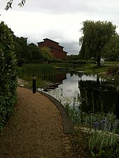
Walton Hall is on the banks of the Ouzel, a tributary of the Great Ouse where Walton Lake, a small balancing lake, has become naturalised and is home to reeds, bulrushes, reed warbler, reed bunting, water rail, sparrowhawk, kestrel, green woodpecker, grass snake and many varieties of odonata. Surrounding the reedbed are ponds and open water, ancient hedgerows and hay meadow.
Walnut Tree

Walnut Tree is a residential district in Walton, with a population of 3,354 in the last UK census. It is named after the Walnut Tree Farm, on whose land the estate was built. All the street names in Walnut Tree are named after either wild flowers and herbs or 18th century turnpike trusts.
Walnut Tree is home to a local centre, including small shopping outlets and takeaway restaurants. The district also contains a GP surgery, a sports injury clinic, a pub and a pet supplies store.
The area features three schools, all operated by the Milton Keynes Education Trust (MKET) – Walton High for secondary education as well as the Heronshaw and Heronsgate schools for primary education, serving both Key Stage 1 and Key Stage 2 respectively.
There is a cricket ground and football pitch with changing facilities. There are a number of play parks for children scattered throughout the area.
Wavendon Gate
Wavendon Gate is a district within the civil parish which borders the village of Wavendon. It is a mainly residential area which contains the Wavendon Gate junior school and also a cricket green and pavilion for recreational activities.
ONS Urban Sub-Areas
Main article: Milton Keynes urban areaFor the 2001 Census, the Office for National Statistics designated urban sub-areas called Walnut Tree and Browns Wood that are far bigger than the districts of that name. The Walnut Tree and Browns Wood urban sub-areas together approximated to that part of the former Newport Pagnell Rural District that is west of the River Ouzel and east of the M1. The ONS discontinued this usage in the 2011 Census.
References
- ^ "Walton". Office for National Statistics. Retrieved 22 April 2024.
- "Contact your parish, town or community council". Milton Keynes Council. 23 October 2020. Archived from the original on 23 October 2020. Retrieved 27 October 2020.
- "MSD Animal Health receives 'breakthrough of the year' award for EXZOLT® at BFREPA conference". 12 October 2018. Archived from the original on 30 October 2020. Retrieved 27 October 2020.
Intervet UK Ltd trading as MSD Animal Health. Registered office Walton Manor, Walton
- Page, William, ed. (1927). "Parishes : Walton". A History of the County of Buckingham. Victoria History of the Counties of England. Vol. 4. London: Constable & Co. Ltd. pp. 485–489.
- "Milton Keynes Campus". The Open University.
- "Biodiversity at Walton Hall Campus". Estates Division, The Open University. 19 December 2016. Retrieved 12 March 2023.
- ^ Page, William, ed. (1927). "Parishes : Walton". A History of the County of Buckingham. Victoria History of the Counties of England. Vol. 4. London: Constable & Co. Ltd. pp. 485–489.
A church existed here in 1225, but the structure of that period was entirely rebuilt about the middle of the 14th century, the date of the present chancel and nave.
- Woodfield, Paul (1986). A guide to the historic buildings of Milton Keynes. Milton Keynes: Milton Keynes Development Corporation. ISBN 978-0903379052.
- "Walton Lake". The Parks Trust. 2021.
- "Walnut Tree (pdf)" (PDF). Archived (PDF) from the original on 26 November 2021. Retrieved 29 September 2012.
- Anne Baker – Street Names of Milton Keynes East ISBN 978-1-86077-411-9
- "Our Schools". www.mket.org.uk. Archived from the original on 3 August 2020. Retrieved 26 June 2020.
- "Welcome". Archived from the original on 23 October 2012. Retrieved 29 September 2012.
- "Wavendon Gate School". Archived from the original on 3 March 2016. Retrieved 29 September 2012.
- "Wavendon Gate Pavilion - Home". www.wavendongatepavilion.com. Archived from the original on 15 April 2012. Retrieved 29 September 2012.
- KS01 Usual resident population: Census 2001, Key Statistics for urban areas Archived 20 August 2011 at the Wayback Machine (lines 1808 to 1815).
See also
- Caldecote, Moulsoe
- Walton (disambiguation) - other places and people named Walton
External links
- "Walton". GENUKI.
- Ordnance Survey (1885). "Buckinghamshire XV (includes: Bletchley, Bow Brickhill, Simpson, Walton, Wavendon and Woughton on the Green.)" (Map). OS Six-inch England and Wales, 1842-1952. 1:10,560. Ordnance Survey – via National Library of Scotland.
![]() Media related to Walton, Milton Keynes at Wikimedia Commons
Media related to Walton, Milton Keynes at Wikimedia Commons