City in Texas, United States
| West Tawakoni, Texas | |
|---|---|
| City | |
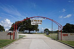
 West Tawakoni City Park West Tawakoni City Park | |
| Nickname: "Catfish Capital of Texas" | |
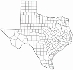
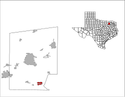
 Location of West Tawakoni, Texas Location of West Tawakoni, Texas | |
 | |
| Coordinates: 32°53′55″N 96°00′18″W / 32.89861°N 96.00500°W / 32.89861; -96.00500 | |
| Country | United States |
| State | Texas |
| County | Hunt |
| Area | |
| • Total | 2.88 sq mi (7.46 km) |
| • Land | 2.82 sq mi (7.31 km) |
| • Water | 0.06 sq mi (0.15 km) |
| Elevation | 456 ft (139 m) |
| Population | |
| • Total | 1,895 |
| • Density | 710.59/sq mi (274.35/km) |
| Time zone | UTC-6 (Central (CST)) |
| • Summer (DST) | UTC-5 (CDT) |
| ZIP code | 75474 |
| Area code(s) | 903, 430 |
| FIPS code | 48-77896 |
| GNIS feature ID | 2412229 |
| Website | www |
West Tawakoni (/təˈwɑːkəni/ tə-WAH-kə-nee) is a city in Hunt County, Texas, United States. The population was 1,895 at the 2020 census. West Tawakoni is located on the west side of Lake Tawakoni, while its twin city East Tawakoni is located on the east side of the lake in Rains County.
Geography
West Tawakoni is located in southeastern Hunt County. It is bordered on three sides by Lake Tawakoni, a reservoir on the Sabine River. To the north is the lake's Caddo Inlet, to the south are Waco Bay and Kitsee Inlet, and to the east is the main body of the lake. Texas State Highway 276 passes through the northern part of the city, leading east across the lake 6 miles (10 km) to East Tawakoni and west the same distance to Quinlan. Greenville, the Hunt county seat, is 22 miles (35 km) to the north via Highway 276 and Highway 34, while downtown Dallas is 48 miles (77 km) to the west.
According to the United States Census Bureau, West Tawakoni has a total area of 2.2 square miles (5.7 km), of which 0.02 square miles (0.04 km), or 0.67%, are water.
Demographics
| Census | Pop. | Note | %± |
|---|---|---|---|
| 1970 | 465 | — | |
| 1980 | 840 | 80.6% | |
| 1990 | 932 | 11.0% | |
| 2000 | 1,462 | 56.9% | |
| 2010 | 1,576 | 7.8% | |
| 2020 | 1,895 | 20.2% | |
| U.S. Decennial Census | |||
| Race | Number | Percentage |
|---|---|---|
| White (NH) | 1,553 | 81.95% |
| Black or African American (NH) | 10 | 0.53% |
| Native American or Alaska Native (NH) | 26 | 1.37% |
| Asian (NH) | 20 | 1.06% |
| Pacific Islander (NH) | 6 | 0.32% |
| Some Other Race (NH) | 1 | 0.05% |
| Mixed/Multi-Racial (NH) | 111 | 5.86% |
| Hispanic or Latino | 168 | 8.87% |
| Total | 1,895 |
As of the 2020 United States census, there were 1,895 people, 742 households, and 453 families residing in the city.
Education
West Tawakoni is served by the Quinlan Independent School District.
Notes
- Note: the US Census treats Hispanic/Latino as an ethnic category. This table excludes Latinos from the racial categories and assigns them to a separate category. Hispanics/Latinos can be of any race.
References
- "The City of West Tawakoni". City of West Tawakoni. Retrieved March 20, 2018.
- "2019 U.S. Gazetteer Files". United States Census Bureau. Retrieved August 7, 2020.
- ^ U.S. Geological Survey Geographic Names Information System: West Tawakoni, Texas
- "U.S. Census website". United States Census Bureau. Retrieved January 31, 2008.
- ^ "Geographic Identifiers: 2010 Census Summary File 1 (G001): West Tawakoni city, Texas". American Factfinder. U.S. Census Bureau. Archived from the original on February 13, 2020. Retrieved March 20, 2018.
- "Population and Housing Unit Estimates". Retrieved May 30, 2019.
- "Census of Population and Housing". Census.gov. Retrieved June 4, 2015.
- "Explore Census Data". data.census.gov. Retrieved May 21, 2022.
- https://www.census.gov/
- "About the Hispanic Population and its Origin". www.census.gov. Retrieved May 18, 2022.
External links
| Municipalities and communities of Hunt County, Texas, United States | ||
|---|---|---|
| County seat: Greenville | ||
| Cities |  | |
| Towns | ||
| Unincorporated communities | ||
| Footnotes | ‡This populated place also has portions in an adjacent county or counties | |