| Wetumpka crater | |
|---|---|
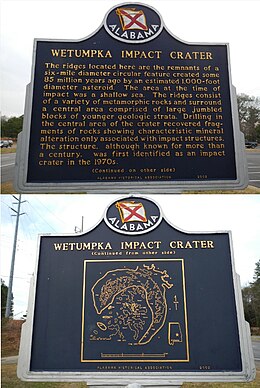
 Wetumpka Impact Crater historic marker Wetumpka Impact Crater historic marker | |
| Impact crater/structure | |
| Confidence | Confirmed |
| Diameter | 4.7 miles (7.6 km) |
| Age | 81.0 ± 1.5 Ma |
| Exposed | Yes |
| Drilled | Yes |
| Bolide type | Chondrite? |
| Country | USA |
| State | Alabama |
| District | Elmore County |
| Municipality | Wetumpka |
The Wetumpka impact crater is the only confirmed impact crater in Alabama, United States. It is located east of downtown Wetumpka in Elmore County. The crater is 4.7 miles (7.6 km) in diameter, and its age is estimated to be about 85 million years (late Cretaceous), based on fossils found in the youngest disturbed deposits, which belong to the Mooreville Chalk Formation.
The crater is well preserved, including the original impact rim and breccia, but exposures are few owing to plant and soil cover, and nearly all are on private land. The meteorite that caused the crater was estimated to be 1,100 feet in diameter and was likely to have impacted at a 30-45 degree angle from the northeast, on a shallow sea that was about 300–400 feet deep.
Thornton L. Neathery discovered the Wetumpka Crater in 1969–70 during regional geological mapping and published the first article on the subject in 1976. However, conclusive evidence of impact origin was lacking until 1998 when David T. King, Jr. and colleagues discovered shocked quartz in a core drilled near the center of the structure. In 2002, Auburn University researchers published evidence and established the site as an internationally recognized impact crater.
References
- "Wetumpka". Earth Impact Database. Planetary and Space Science Centre University of New Brunswick Fredericton. Retrieved 2014-04-03.
- "Wetumpka Meteor Crater". Archived from the original on 17 Mar 2005. Retrieved 2014-04-03.
- "Impact Crater". Wetumpka Area Chamber of Commerce. Archived from the original on 10 January 2018. Retrieved 4 Mar 2017.
The location of the Wetumpka Astrobleme —"star-wound"— originated from a cosmic event that occurred some 80 to 83 million years ago. It was confirmed only recently, after more than two years of extensive investigation and deep earth core drilling conducted on site. It is one of the few above-ground impact crater locations in the United States and one of only about six in the entire World. Even more unusual is the fact that the structure is actually exposed (as you can see from the rim evidence in these photographs). Despite the weathering that has occurred through millions of years, the crater walls are still prominent, so the rim was obviously much higher at one time. The projectile of the meteor impact was probably travelling between 10 and 20 miles per second. So this means the impact would have produced winds in excess of 500 miles per hour, and the meteor most likely struck at a 30-45 degree angle as it came from the northeast. They determined that it came from the northeast by the angle at which the rocks are slanted within the impact area which includes the current flow path of the Coosa River. This can be seen looking from both directions on the Bibb Graves Bridge. Geologists speculate that the shock waves, the damage, and other effects of the impact explosion radiated out from the strike several hundred miles. Debris may have been thrown as far away as the present Gulf of Mexico. Geologists also theorize that the strike area would have been under a shallow sea, perhaps 300 to 400 feet of water, that covered most of southern Alabama at the time of the impact. It is estimated that the diameter of the meteorite to be 1,100 feet and could have been as much as three to four times larger.
- "Wetumpka Impact Crater". Wetumpka Public Library. Archived from the original on September 28, 2007. Retrieved 2007-08-21.
32°31′N 86°10′W / 32.517°N 86.167°W / 32.517; -86.167
Categories:
