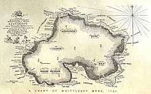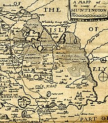

Whittlesea Mere was an area of open water in the Fenland area of the county of Huntingdonshire (now Cambridgeshire), England. The mere occupied the land southeast of Yaxley Fen, south of Farcet Fen and north of Holme Fen. The town of Whittlesey lay to the northeast.
Whittlesea Mere was the last of the 'great meres' to be drained. The old course of the River Nene took it into the mere on one side and out on the other. The area covered by water was at least 1,870 acres (756 hectares) in summer, extending to 3,000 acres (1,214 ha) in winter. The mere was a source of fish, wildfowl, reed and sedge for local inhabitants, and also provided a setting for 'water picnics' for the region's nobility.
According to the traveller Celia Fiennes, who saw it in 1697, the mere was "3 mile broad and six mile long. In the midst is a little island where a great store of Wildfowle breed.... The ground is all wett and marshy but there are severall little Channells runs into it which by boats people go up to this place; when you enter the mouth of the Mer it looks formidable and its often very dangerous by reason of sudden winds that will rise like Hurricanes...."

History
Before drainage, the fens contained many shallow lakes, of which Whittlesey Mere was the largest. The River Nene originally flowed through this mere, then south to Ugg Mere, before turning east towards the Ouse. The mere was one of the locations of Lord Orford’s Voyage Round The Fens in 1774 By 1851, silting and peat expansion had reduced Whittlesey Mere to about 400 ha and only a metre deep.
Drainage


The construction of a new main drain of the Middle Level Navigations to Wiggenhall St Germans completed in 1848, enabled the mere to be drained. A pumping station with an Appold centrifugal pump was used to achieve this, rather than the more traditional scoop wheel. The pump had been shown for the first time at the Great Exhibition in 1851 and its inventor was commissioned to design a pump for the draining of the mere. It was 4.5 feet (1.4 m) in diameter, and powered by a 25 hp (19 kW) steam engine, could raise 101 tons of water per minute by 2 or 3 feet (0.6 or 0.9 m).
The project was funded by a group of gentlemen and local landowners: William Wells of Holmewood; Heathcote of Conington Castle; Edward Fellowes of Ramsey Abbey; Thornhill of Diddington; Lord Sandwich; and Wentworth Fitzwilliam of Milton.
The drainage turned both the mere and Holme Fen into usable farmland, but subsidence followed.
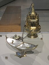
A thurible and other silver items were found in the bed of the mere and from the ram's head on one of these pieces were believed to have come from Ramsey Abbey. The thurible (or censer), incense boat and a sword are now in the Victoria & Albert Museum. Also found in the bed were blocks of quarried stone, which are supposed to have fallen from a barge on their way to the Abbey.
A flood occurred in 1852 and the mere filled with water, but it was drained again. In 1862, the Marshland Sluice gave way under pressure from the tide and water flooded in. It was drained once more and farming resumed.
Modern day
The name 'Whittlesea Mere' remains on maps to this day, although the only water is to be found in farmers' irrigation reservoirs and dykes draining the fertile farmland. Stage 3 of the Great Fen Project may eventually see the mere return to wetland, although the lake bed is now higher than the former shoreline due to the uneven shrinkage of the surrounding peat as it has dried. Subsidence of four metres since 1852 is shown visually at Holme Posts.
Local legends
A local legend, first recounted in The Leisure Hour (1887) by a writer who claimed to have heard it from the principal actor, tells of a cottager's son from Holme who while employed bird scaring on Holme Fen one Sunday in February, 1851, wandered from his post and sank up to his armpits in the reed beds of Whittlesey Mere. Obscured from view, he remained stuck for 19 hours, which he ascertained from the sound of the bells of All Saints Church, Conington, until a fellow villager found him by chance, extricated him and returned him to his parents.
References
- "Streetmap.co.uk- search results for 522500,290500". www.streetmap.co.uk. Archived from the original on 24 May 2011.
- The Journeys of Celia Fiennes. Edited and introduced by Christopher Morris (London: The Cresset Press, 1949), p. 67.
- "Lord Orford's Voyage round the fens". www.huntshistoryfest.com. Retrieved 18 February 2021.
- "St Germans Pumping Station: History". Middle Level Commissioners. Archived from the original on 9 October 2013. Retrieved 13 September 2013.
- Hinde, K. S. G. (2006). Fenland Pumping Engines. Landmark Publishing Ltd. pp. 38–40. ISBN 978-1-84306-188-5.
- Page, William; Proby, Granville; Ladds, S Inskip, eds. (1936). "The Middle Level of the Fens and its reclamation". A History of the County of Huntingdon. Victoria County History. Vol. 3. pp. 249–290. Retrieved 30 December 2010.
- "The Ramsey Abbey Censer".
- "The Ramsey Abbey Censer".
- "The Ramsey Abbey Incense Boat".
- "Sword".
- "Ramsey Abbey Stones". Yaxley History.
- Wentworth Day, J. (1954). A History of the Fens. George G. Harrap & Co. Ltd, London.
- "Great Fen Project".
- "'Weirder than any other landscape': a wild walk in the Fens". the Guardian. 22 April 2018. Retrieved 26 January 2023.
- "Holme Fen Posts | The Great Fen". www.greatfen.org.uk. Retrieved 26 January 2023.
- Saunders, W.H. Bernard (1891). "A Legend of Whittlesey Mere". Fenland Notes & Queries. 1: 156–158.
- James, Maureen (2014), "Of the Fens and Farming: The Legend of Whittlesey Mere", Cambridgeshire Folk Tales, History Press, ISBN 9780752466286
External links
52°29′59″N 0°12′03″W / 52.4996°N 0.2007°W / 52.4996; -0.2007
Categories: