Human settlement in England
| Wimbledon Chase | |
|---|---|
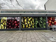
 Former Royal Arsenal Co-operative Society mosaic sign at Wimbledon Chase Former Royal Arsenal Co-operative Society mosaic sign at Wimbledon Chase | |
| OS grid reference | TQ 24 69 |
| London borough | |
| Ceremonial county | Greater London |
| Region | |
| Country | England |
| Sovereign state | United Kingdom |
| Post town | LONDON |
| Postcode district | SW19 & SW20 |
| Dialling code | 020 |
| Police | Metropolitan |
| Fire | London |
| Ambulance | London |
| UK Parliament | |
| London Assembly | |
Wimbledon Chase is a south-west London suburb part of the wider Wimbledon area. It takes its name from Wimbledon Chase railway station and thus it is an informal definition: parts vie with the definitions of Merton Park, which has a tram link stop to the east of Wimbledon Chase station. Also contemporary suburb names which compete with the definition of this modestly-sized district of Merton to the west and south are Raynes Park and South Merton, respectively.
The area contains Wimbledon Chase Primary School and is largely residential in character, with a small parade of shops on Kingston Road (including a Co-operative Food, a Tesco Express and a BP garage with an M&S concession).
History
Local geography
| Places adjacent to Wimbledon Chase | ||||||||||||||||
|---|---|---|---|---|---|---|---|---|---|---|---|---|---|---|---|---|
| ||||||||||||||||
References
- "Station details at National Rail". Retrieved 13 March 2013.
- "Primary school entry on LB Merton website". Retrieved 13 March 2013.
51°24.6′N 0°12.7′W / 51.4100°N 0.2117°W / 51.4100; -0.2117
Categories: