Human settlement in England
| Wykeham | |
|---|---|
 | |
| Population | 280 (2011 census) |
| OS grid reference | SE964834 |
| Civil parish |
|
| Unitary authority | |
| Ceremonial county | |
| Region | |
| Country | England |
| Sovereign state | United Kingdom |
| Post town | SCARBOROUGH |
| Postcode district | YO13 |
| Police | North Yorkshire |
| Fire | North Yorkshire |
| Ambulance | Yorkshire |
| UK Parliament | |
| 54°14′14″N 0°31′19″W / 54.23728°N 0.52201°W / 54.23728; -0.52201 | |

Wykeham is a small village and civil parish in the Scarborough district of North Yorkshire, England, on the outskirts of Scarborough and the southern boundary of the North York Moors National Park.
It consists of a main street adjacent to the only pub; The Downe Arms. It lies around 7 miles (11 km) away from Scarborough and surrounding villages include: East Ayton, West Ayton, Snainton, Hutton Buscel, Brompton and Ruston. It has a cricket ground also which is hidden away in a small turning off the main road. To the north of the village is Wykeham Forest, which covers over 1,114 acres (451 ha).
According to the 2011 UK census, Wykeham parish had a population of 280, a decrease on the 2001 UK census figure of 290. In 2015, North Yorkshire County Council estimated that population had remained static at 280.
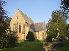
A nunnery was established at Wykeham between 1140 and 1160 that was located to the south east of the village. The Anglican church in the village is a grade II* listed building. St Helen's and All Saints Parish Church was built between 1853 and 1855 by William Butterfield. A primary school is tied to the church. Wykeham Church of England Primary School, which has a nominal capacity of 60 pupils, was rated Good by Ofsted in 2016.
Charm Park, a Point-to-point racecourse is close by the village, as are the Wykeham Lakes.
See also
References
- ^ UK Census (2011). "Local Area Report – Wykeham Parish (1170217371)". Nomis. Office for National Statistics. Retrieved 5 March 2018.
- "Wykeham Forest, Scarborough - area information, map, walks and more". getoutside.ordnancesurvey.co.uk. Retrieved 14 October 2021.
- "Wykeham Forest Plan". forestryengland.uk. Retrieved 14 October 2021.
- UK Census (2001). "Local Area Report – Wykham Parish (36UG051)". Nomis. Office for National Statistics. Retrieved 14 October 2021.
- "2015 Population Estimates Parishes" (PDF). northyorks.gov.uk. December 2016. p. 17. Archived from the original (PDF) on 4 June 2022. Retrieved 14 October 2021.
- Jennings, B (1999). Yorkshire Monasteries. ISBN 1-85825-105-2.
- "St Helen & All Saints Parish Church". www.achurchnearyou.com. Retrieved 14 October 2021.
- Historic England. "All Saints Church (Grade II*) (1316131)". National Heritage List for England. Retrieved 14 October 2021.
- "Wykeham Church of England Voluntary Controlled Primary School URN: 121526". reports.ofsted.gov.uk. 8 October 2020. Retrieved 14 October 2021.
- Wood, Alexandra (9 February 2021). "North Yorkshire Water Park near Scarborough invests £1m in new facilities including first wakeboarding line in county". The Yorkshire Post. Retrieved 14 October 2021.
External links
![]() Media related to Wykeham at Wikimedia Commons
Media related to Wykeham at Wikimedia Commons
This Scarborough location article is a stub. You can help Misplaced Pages by expanding it. |