 | |
 | |
| Native name | 山国川 (Japanese) |
|---|---|
| Location | |
| Island | Kyushu |
| Region | Ōita Prefecture, Fukuoka Prefecture |
| Physical characteristics | |
| Mouth | |
| • location | Yoshitomi, Fukuoka, Nakatsu, Ōita |
| • coordinates | 33°37′06″N 131°11′10″E / 33.618281°N 131.186234°E / 33.618281; 131.186234 |
| Length | 56 km (35 mi) |
| Basin size | 540 km (210 sq mi) |
| Discharge | |
| • maximum | 4800 cubic meters/s in 1944 |
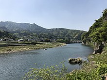
The Yamakuni River (山国川, Yamakuni-gawa) is a river that flows through the Ōita Prefecture in Japan. In its lower reaches it provides the boundary to the Fukuoka Prefecture to the west.

The Yamakuni River arises on the slopes of the sacred Mount Hiko on the border of Oita and Fukuoka prefectures, flowing towards the sea through the Yabakei and Nakatsu plains, and empties into the Seto Inland Sea. Tributaries include the Yamaoi River, Atoda River and Yamautsuri River.
It is known as the largest rapid river in Kyushu, and when torrential rain occurs in the upper reaches, a large amount of rain flows down in a short time, which has the characteristic of causing flooding.
Structures

The Yabakei Dam on a tributary, the Yamautsuri River, and Heisei Ozeki Barrage, help control the river system.

The Yabakei Bridge over it, is the longest stone bridge in Japan.
Tourism
It runs through the Yabakei Gorge (Shinyabakei Gorge) and is adjacent to Aonodōmon (Blue Tunnel) in the Yaba-Hita-Hikosan Quasi-National Park. Its upper reaches include the scenic Marinkyo Gorge.
History
Significant floods have occurred in September 1944 (typhoon), September 1993 (typhoon) and July 2012. Drought is also frequent and was recorded in 9 of the first 31 years after the construction of the Heisei flood barrier.
References
- ^ "山国川". Retrieved 1 October 2022.
- "Yabakei Dam". Structurae. Retrieved 1 October 2022.
- "Heisei Ozeki Dam". Structurae. Retrieved 1 October 2022.
- 文化審議会の答申(国宝・重要文化財(建造物)の指定)について [On the Report of the Council of Cultural Affairs (Designation of National Treasures and Important Cultural Properties (Structures))] (PDF) (in Japanese). Agency for Cultural Affairs. 20 May 2022. Retrieved 23 May 2022.
- 耶馬渓橋 [Yabakei Bridge] (in Japanese). Nakatasu City. 9 May 2017. Retrieved 23 May 2022.
- 耶馬渓橋が国の重要文化財に指定されることが決定しました! [Decision on the Designation of Yabakei Bridge as a National Important Cultural Property!] (PDF) (in Japanese). Nakatasu City. 21 May 2022. Retrieved 23 May 2022.
- 耶馬渓橋が国の重要文化財に指定決定! [Decision to Designate Yabakei Bridge a National Important Cultural Property!] (PDF) (in Japanese). Nakatasu City. May 2022. Retrieved 23 May 2022.
| |||||||||||||||
| |||||||||||||||
| |||||||||||||||
| |||||||||||||||