| Yli | |
|---|---|
| Village | |
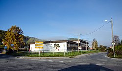
 View of the village school which closed in 2014 View of the village school which closed in 2014 | |
  | |
| Coordinates: 59°33′21″N 9°12′05″E / 59.5557°N 9.20136°E / 59.5557; 9.20136 | |
| Country | Norway |
| Region | Eastern Norway |
| County | Telemark |
| District | Aust-Telemark |
| Municipality | Notodden Municipality |
| Area | |
| • Total | 0.24 km (0.09 sq mi) |
| Elevation | 88 m (289 ft) |
| Population | |
| • Total | 291 |
| • Density | 1,198/km (3,100/sq mi) |
| Time zone | UTC+01:00 (CET) |
| • Summer (DST) | UTC+02:00 (CEST) |
| Post Code | 3677 Notodden |
Yli is a village in Notodden Municipality in Telemark county, Norway. The village is located about 5 kilometres (3.1 mi) to the west of the town of Notodden and about 3 kilometres (1.9 mi) to the southeast of the village of Heddal. The river Heddøla flows past the village just before emptying into the lake Heddalsvatnet about 1.5 kilometres (0.93 mi) east of the village.
The 0.24-square-kilometre (59-acre) village has a population (2022) of 291 and a population density of 1,198 inhabitants per square kilometre (3,100/sq mi).
Notodden Airport and the European route E134 highway are both located just north of the village.
References
- ^ Statistisk sentralbyrå (1 January 2022). "Urban settlements. Population and area, by municipality".
- "Yli, Notodden". yr.no. Retrieved 26 August 2023.
- ^ Lundbo, Sten, ed. (28 December 2022). "Yli". Store norske leksikon (in Norwegian). Kunnskapsforlaget. Retrieved 26 August 2023.
This Telemark location article is a stub. You can help Misplaced Pages by expanding it. |