Human settlement in England
| Yockenthwaite | |
|---|---|
 Yockenthwaite Yockenthwaite | |
 | |
| OS grid reference | SD905790 |
| Civil parish | |
| Unitary authority | |
| Ceremonial county | |
| Region | |
| Country | England |
| Sovereign state | United Kingdom |
| Police | North Yorkshire |
| Fire | North Yorkshire |
| Ambulance | Yorkshire |
| UK Parliament | |
| 54°12′24″N 2°08′50″W / 54.20665°N 2.14714°W / 54.20665; -2.14714 | |
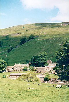
Yockenthwaite is a hamlet in the Craven district of North Yorkshire, England. It lies in the Langstrothdale valley in the Yorkshire Dales National Park. Historically part of the West Riding of Yorkshire, Yockenthwaite is 20 miles (32 km) north of Skipton and 8 miles (13 km) south of Hawes. The name of the hamlet is said to derive from Eoghan's clearing in a wood.
Yockenthwaite lies on the north bank of the River Wharfe. It is better known than may be expected because a children's television character from The Rottentrolls takes its name from the hamlet.
The hamlet is connected to the road that winds up and down Langstrothdale by a grade II listed bridge from the early 18th century. This is the only route into and out of the hamlet by road.
Yockenthwaite stone circle

Just to the west of the village by Yockenthwaite Cave, are some ancient stones arranged in a circle. The stones, which are now a scheduled monument, are 25 feet (7.6 m) in diameter and believed to be Bronze Age in origin. The overall size and layout of the stones gave rise to the nickname of the Giant's Grave. Some of the stones have been taken and re-used for drystone walls and buildings.
Speight refers to the site as a "druid's circle" and whilst it has been described as a stone circle, it is believed to be a ring cairn. Whilst 23 stones remain extant, there are spaces for three to four more stones in the circle, which have been removed.
See also
References
- "A wildlife walk in Upper Wharfedale, North Yorkshire | Great British walks". The Guardian. 12 May 2012. Retrieved 12 January 2020.
- Rowe, Mark (3 October 2017). "Great winter walks: Upper Wharfedale". The Telegraph. Retrieved 12 January 2020.
- Burn, Chris (7 October 2019). "How children's TV show gave Yorkshire Dales hamlet a quirky claim to fame". The Yorkshire Post. Retrieved 12 January 2020.
- Historic England. "The Bridge (Grade II) (1132216)". National Heritage List for England. Retrieved 12 January 2020.
- "OL30" (Map). Yorkshire Dales - Northern & Central Area. 1:25,000. Explorer. Ordnance Survey. 2016. ISBN 9780319263358.
- "Discover Langstrothdale". National Trust. Retrieved 12 January 2020.
- David Raven (2004). "Yockenthwaite - Stone Circle". The Megalithic Portal. Retrieved 3 July 2007.
- Historic England. "Yockenthwaite small stone circle (1008772)". National Heritage List for England. Retrieved 12 January 2020.
- "Out of Oblivion: A landscape through time". www.outofoblivion.org.uk. Retrieved 12 January 2020.
- Marsh, Terry (2018). The Dales Way : from Ilkley to the Lake District through the Yorkshire Dales (3 ed.). Kendal: Cicerone. p. 88. ISBN 978-1-85284-943-6.
- Speight, Harry (1900). Upper Wharfedale : being a complete account of the history, antiquities and scenery of the picturesque valley of the Wharfe, from Otley to Langstrothdale. London: E Stock. p. 496. OCLC 1079273371.
- Barnett, John. "The Design and Distribution of Stone Circles in Britain; a Reflection of Variation in Social Organization in the Second and Third Millennia BC," (PDF). etheses.whiterose.ac.uk. p. 78. Retrieved 12 January 2020.
External links
![]() Media related to Yockenthwaite at Wikimedia Commons
Media related to Yockenthwaite at Wikimedia Commons
This North Yorkshire location article is a stub. You can help Misplaced Pages by expanding it. |