| Yurajcocha | |
|---|---|
| Tintayari / Huampuni | |
 | |
| Location | Peru Junín Region |
| Coordinates | 12°33′06″S 75°29′24″W / 12.55167°S 75.49000°W / -12.55167; -75.49000 |
| Max. length | 5 km (3.1 mi) |
| Max. width | 0.84 km (0.52 mi) |
| Surface elevation | 4,466 m (14,652 ft) |
| Yurajcocha Dam | |
|---|---|
 | |
| Dam and spillways | |
| Height | 10.2 m (33 ft) |
| Power Station | |
| Operator(s) | Electroperu |
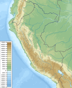
Yurajcocha (possibly from Quechua yuraq white, qucha lake, "white lake"), Tintayari or Huampuni (possibly from Aymara wampu boat, -ni, a suffix, "the one with a boat") is a lake in Peru located in the Junín Region, Huancayo Province, Chongos Alto District. It is situated at a height of approximately 4,466 metres (14,652 ft), about 5 km long and 0.84 km at its widest point. Yurajcocha lies north of Acchicocha and northeast of Huichicocha. The lake belongs to the watershed of the Mantaro River.
In 1999 the Yurajcocha dam was built at the northern end of the lake at 12°31′56.8″S 75°29′46.49″W / 12.532444°S 75.4962472°W / -12.532444; -75.4962472. The dam is 10.2 m (11.2 yd) high. It is operated by Electroperu.
References
- Teofilo Laime Ajacopa (2007). Diccionario Bilingüe: Iskay simipi yuyayk’anch: Quechua – Castellano / Castellano – Quechua (PDF). La Paz, Bolivia: futatraw.ourproject.org.
- escale.minedu.gob.pe - UGEL map of the Huancayo Province (Junín Region)
- ^ Obras hidraulicos en la cuenca de Mantaro - fuente : fuente: Electroperu - Inventario proyectos de afianzamiento hidrico Cuenca del Rio Mantaro, 2005
This Junín Region geography article is a stub. You can help Misplaced Pages by expanding it. |