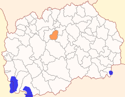
| Municipality of Zelenikovo Општина Зелениково | |
|---|---|
| Rural municipality | |
 Flag Flag | |
 | |
| Country | |
| Region | |
| Municipal seat | Zelenikovo |
| Government | |
| • Mayor | Kosta Manevski (VMRO-DPMNE) |
| Area | |
| • Total | 176.95 km (68.32 sq mi) |
| Population | |
| • Total | 3,361 |
| • Density | 19/km (49/sq mi) |
| Time zone | UTC+1 (CET) |
| Area code | 02 |
| Car Plates | SK |
Zelenikovo Municipality (Macedonian: Зелениково) is a municipality in the central part of North Macedonia. The municipal seat is located in the village Zelenikovo. The municipality is located in the Skopje Statistical Region.
Geography
The municipality borders Studeničani Municipality to the west, Petrovec Municipality to the northeast, Čaška Municipality to the south, and Veles Municipality to the southeast.
Demographics
According to the 2021 North Macedonia census, Zelenikovo Municipality has 3,361 inhabitants. Ethnic groups in the municipality:
| 1953 | 1961 | 1971 | 1981 | 1994 | 2002 | 2021 | ||||||||
| Number | % | Number | % | Number | % | Number | % | Number | % | Number | % | Number | % | |
| TOTAL | 5,284 | 100 | 4,696 | 100 | 4,109 | 100 | 4,363 | 100 | 4,236 | 100 | 4,077 | 100 | 3,361 | 100 |
| Macedonians | 1,679 | 31.8 | 1,877 | 40.0 | 2,035 | 49.5 | 2,198 | 50.4 | 2,384 | 56.3 | 2,522 | 61.9 | 2,407 | 71.62 |
| Albanians | 1,680 | 31.8 | 1,187 | 25.3 | 773 | 18.8 | 1,511 | 34.6 | 1,543 | 36.4 | 1,206 | 29.6 | 415 | 12.35 |
| Bosniaks | 191 | 4.7 | 187 | 5.56 | ||||||||||
| Turks | 1,765 | 33.4 | 1,426 | 30.4 | 849 | 20.7 | 266 | 6.1 | 11 | 0.3 | 1 | 0.02 | 5 | 0.15 |
| Other / Undeclared / Unknown | 160 | 3.0 | 206 | 4.4 | 452 | 11.0 | 398 | 8.9 | 298 | 7.0 | 157 | 3.8 | 102 | 3.03 |
| Persons for whom data are taken from administrative sources | 245 | 7.29 | ||||||||||||
References
- 2002 census results in English and Macedonian (PDF)
- "Попис на населението, домаќинствата и становите во Република Северна Македонија, 2021 - прв сет на податоци" (PDF). stat.gov.mk. Retrieved 22 July 2022.
External links
| Villages in Zelenikovo Municipality | |
|---|---|
| Seat: | |
| Village(s): | |
41°52′59″N 21°35′22″E / 41.88306°N 21.58944°E / 41.88306; 21.58944
Categories: