| Adour | |
|---|---|
 Adour seen from the bridge at Aire-sur-l'Adour Adour seen from the bridge at Aire-sur-l'Adour | |
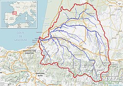
 Adour River watershed (Interactive map) Adour River watershed (Interactive map) | |
| Native name | L'Adour (French) |
| Location | |
| Country | France |
| Physical characteristics | |
| Source | |
| • location | High-Bigorre |
| • elevation | 2,200 m (7,200 ft) |
| Mouth | |
| • location | Atlantic Ocean |
| • coordinates | 43°31′46″N 1°31′25″W / 43.52944°N 1.52361°W / 43.52944; -1.52361 |
| Length | 308 km (191 mi) |
| Basin size | 16,880 km (6,520 sq mi) |
| Discharge | |
| • average | 150 m/s (5,300 cu ft/s) |
The Adour (French pronunciation: [aduʁ] ; Basque: Aturri; Occitan: Ador) is a river in southwestern France. It rises in High-Bigorre (Pyrenees), in the commune of Aspin-Aure, and flows into the Atlantic Ocean (Bay of Biscay) near Bayonne. It is 308.3 kilometres (191.6 mi) long, of which the uppermost ca. 11 kilometres (6.8 mi) is known as the Adour de Payolle. At its final stretch, i.e. on its way through Bayonne and a short extent upstream, the river draws the border between the Northern Basque Country and Landes regions.
Places along the river
Départements and towns along the river include:
- Hautes-Pyrénées: Bagnères-de-Bigorre, Tarbes, Maubourguet
- Gers: Riscle
- Landes: Aire-sur-l'Adour, Dax, Tarnos
- Pyrénées-Atlantiques: Bayonne
Tributaries

The main tributaries of the Adour are, from source to mouth:
- Adour de Gripp (also Adour du Tourmalet, 15 km)
- Adour de Lesponne (19 km)
- Échez (64 km)
- Arros (130 km)
- Léez (56 km)
- Gabas (117 km)
- Midouze (151 km)
- Louts (86 km)
- Luy (154 km)
- Gave de Pau (191 km)
- Bidouze (82 km)
- Aran (48 km)
- Ardanabia (26 km)
- Nive (79 km)
References
External links
- Commission Européenne—Natura 2000: Cartographie du Barthes de l'Adour—(in French) — maps of the Adour and Adour Basin.
- Natura 2000 Sites d'Intérêt Communautaire par la France: Barthes de l'Adour — (in French)
- Adour Archived 2014-11-10 at the Wayback Machine—(in French) — website homepage.
- European Commission: official Natura 2000 Network website— — "the centrepiece of EU nature & biodiversity policy."
This Occitania geographical article is a stub. You can help Misplaced Pages by expanding it. |
This Nouvelle-Aquitaine geographical article is a stub. You can help Misplaced Pages by expanding it. |
This article related to a river in France is a stub. You can help Misplaced Pages by expanding it. |
- Adour basin
- Rivers of Nouvelle-Aquitaine
- Rivers of Occitania (administrative region)
- Natura 2000 in France
- Rivers of Gers
- Rivers of Hautes-Pyrénées
- Rivers of Landes (department)
- Rivers of Pyrénées-Atlantiques
- Rivers of France
- Protected areas of the Pyrenees
- Occitania (administrative region) geography stubs
- Nouvelle-Aquitaine geography stubs
- France river stubs