| Alūksne | |
|---|---|
| District | |
 | |
| Coordinates: 57°25′N 27°0′E / 57.417°N 27.000°E / 57.417; 27.000 | |
| Country | Latvia |
| Area | |
| • Total | 2,243 km (866 sq mi) |
| Population | |
| • Total | 24,159 |
| • Density | 11/km (28/sq mi) |
| Website | aluksne.lv |
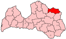
Alūksne district (Latvian: Alūksnes rajons) was an administrative division of Latvia, located in Vidzeme region, in the country's north-east, 202 km (126 mi) from the capital city Riga. The district had international borders with Estonia (border 103.8 km/64.35 miles) and Russia (border 46.4 km/28.77 miles), and internal borders with the districts of Valka (51.7 km/32.05 miles), Gulbene (98.1 km/60.83 miles) and Balvi (57.4 km/35.58 miles). The main city in the district was Alūksne.
After the administrative-territorial reform of 2009 the Alūksne district was divided between Alūksne Municipality and Ape Municipality.
Cities and parishes in the Alūksne district
- Alūksne town
- Ape town
- Alsviķi parish
- Anna parish
- Gaujiena parish
- Ilzene parish
- Jaunalūksne parish
- Jaunanna parish
- Jaunlaicene parish
- Kalncempji parish
- Liepna parish
- Maliena parish
- Mālupe parish
- Mārkalne parish
- Pededze parish
- Trapene parish
- Veclaicene parish
- Vireši parish
- Zeltiņi parish
- Ziemeri parish
References
- "RESIDENT POPULATION BY REGION, CITY AND DISTRICT AT THE BEGINNING OF THE YEAR". Centrālās statistikas pārvaldes datu bāzes. Archived from the original on 2009-01-10. Retrieved 23 January 2009.
| Defunct counties and districts of Latvia | |
|---|---|
| Former counties (dissolved before 1949) | |
| Former districts (dissolved 2009) |
|
This Vidzeme location article is a stub. You can help Misplaced Pages by expanding it. |