| Albis | |
|---|---|
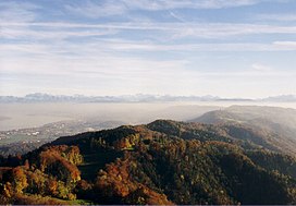
 The Albis chain as seen from the Uetliberg, looking southeast. In the background left the Glärnisch. The Albis chain as seen from the Uetliberg, looking southeast. In the background left the Glärnisch. | |
| Highest point | |
| Coordinates | 47°17′N 8°30′E / 47.283°N 8.500°E / 47.283; 8.500 |
| Geography | |
 | |
| Country | Switzerland |
| Canton | Zürich |
The Albis is a chain of hills in the Canton of Zürich, Switzerland.
Localisation
A paronamic tower allows to observe the landscape.
Picture gallery
-
 Hiking trail from Felsenegg to Uetliberg as seen near Balderen.
-
So called Fallätsche at Zürich-Leimbach, Wollishofen quarter in the foreground.
-
Leimbach (Zürich), lower Sihltal and Albis hills, as seen from Käferberg
-
 360° panorama from Albis Hochwacht
References
- "Du col de l'Albis à la vallée de la Sihl". www.suisse-rando.ch (in French). Retrieved 2024-11-06.

