Commune in Nouvelle-Aquitaine, France
| Ambès | |
|---|---|
| Commune | |
 Port Port | |
 Coat of arms Coat of arms | |
| Location of Ambès | |
  | |
| Coordinates: 45°00′44″N 0°32′22″W / 45.0122°N 0.5394°W / 45.0122; -0.5394 | |
| Country | France |
| Region | Nouvelle-Aquitaine |
| Department | Gironde |
| Arrondissement | Bordeaux |
| Canton | La Presqu'île |
| Intercommunality | Bordeaux Métropole |
| Government | |
| • Mayor (2023–2026) | Gilbert Dodogaray |
| Area | 28.85 km (11.14 sq mi) |
| Population | 3,207 |
| • Density | 110/km (290/sq mi) |
| Time zone | UTC+01:00 (CET) |
| • Summer (DST) | UTC+02:00 (CEST) |
| INSEE/Postal code | 33004 /33810 |
| Elevation | 0–8 m (0–26 ft) (avg. 4 m or 13 ft) |
| French Land Register data, which excludes lakes, ponds, glaciers > 1 km (0.386 sq mi or 247 acres) and river estuaries. | |
Ambès (French pronunciation: [ɑ̃bɛs]; Occitan: Ambés) is a commune in the Gironde department in southwestern France.
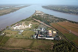
It is located at the point, the Bec d'Ambès (Occ. bèc is cognate with Old English bæc for beck), where the rivers Garonne and Dordogne meet to form the Gironde estuary.
Population
| Year | Pop. | ±% p.a. |
|---|---|---|
| 1968 | 2,243 | — |
| 1975 | 2,545 | +1.82% |
| 1982 | 2,715 | +0.93% |
| 1990 | 2,567 | −0.70% |
| 1999 | 2,824 | +1.07% |
| 2007 | 2,931 | +0.47% |
| 2012 | 2,882 | −0.34% |
| 2017 | 3,128 | +1.65% |
| Source: INSEE | ||
See also
Gallery

References
- "Répertoire national des élus: les maires" (in French). data.gouv.fr, Plateforme ouverte des données publiques françaises. 6 June 2023.
- "Populations légales 2021" (in French). The National Institute of Statistics and Economic Studies. 28 December 2023.
- J. Verneilh-Puyraseau, Histoire politique et statistique de l'Aquitaine, ou des pays compris entre la Loire et les Pyrénées, l'Océan et les Cévennes, Tome I, p. 130
- Population en historique depuis 1968, INSEE
This Gironde geographical article is a stub. You can help Misplaced Pages by expanding it. |
