| Anderen | |
|---|---|
| Village | |
 Farm in Anderen Farm in Anderen | |
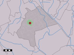
 The village (dark red) and the statistical district (light green) of Anderen in the municipality of Aa en Hunze. The village (dark red) and the statistical district (light green) of Anderen in the municipality of Aa en Hunze. | |
  | |
| Coordinates: 53°0′1″N 6°41′8″E / 53.00028°N 6.68556°E / 53.00028; 6.68556 | |
| Country | Netherlands |
| Province | Drenthe |
| Municipality | Aa en Hunze |
| Area | |
| • Total | 11.06 km (4.27 sq mi) |
| Elevation | 12 m (39 ft) |
| Population | |
| • Total | 265 |
| • Density | 24/km (62/sq mi) |
| Time zone | UTC+1 (CET) |
| • Summer (DST) | UTC+2 (CEST) |
| Postal code | 9465 |
| Dialing code | 0592 |
Anderen is a village in the Dutch province of Drenthe. It is a part of the municipality of Aa en Hunze, and lies about 8 km east of Assen.
The village was first mentioned in 1217 as Anderne. The etymology is unknown. Anderen is an esdorp without a church which developed in the Early Middle Ages on the Hondsrug.
Anderen was home to 121 people in 1840.
Transportation
There is no railway station here. The nearest station is Assen station. There are no bus services either, but bus services 10 and 28 stop 1 km south of Anderen on the road cbs.
For further information see Aa en Hunze#Transportation.
Gallery
References
- ^ "Kerncijfers wijken en buurten 2021". Central Bureau of Statistics. Retrieved 10 April 2022.
- "Postcodetool for 9465TJ". Actueel Hoogtebestand Nederland (in Dutch). Het Waterschapshuis. Retrieved 10 April 2022.
- "Anderen - (geografische naam)". Etymologiebank (in Dutch). Retrieved 10 April 2022.
- Ronald Stenvert (2001). Anderen (in Dutch). Zwolle: Waanders. p. 61. ISBN 90 400 9454 3. Retrieved 10 April 2022.
- "Anderen". Plaatsengids (in Dutch). Retrieved 10 April 2022.
| Populated places in the municipality of Aa en Hunze | |
|---|---|
| Villages | |
| Hamlets | |
This Drenthe location article is a stub. You can help Misplaced Pages by expanding it. |

