| Gieterveen | |
|---|---|
| Village | |
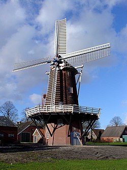
 The windmill The windmill | |
 Flag Flag | |
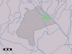
 The village centre (dark green) and the statistical district (light green) of Gieterveen in the municipality of Aa en Hunze. The village centre (dark green) and the statistical district (light green) of Gieterveen in the municipality of Aa en Hunze. | |
  | |
| Coordinates: 53°1′38″N 6°50′16″E / 53.02722°N 6.83778°E / 53.02722; 6.83778 | |
| Country | Netherlands |
| Province | Drenthe |
| Municipality | Aa en Hunze |
| Area | |
| • Total | 15.40 km (5.95 sq mi) |
| Elevation | 4 m (13 ft) |
| Population | |
| • Total | 875 |
| • Density | 57/km (150/sq mi) |
| Time zone | UTC+1 (CET) |
| • Summer (DST) | UTC+2 (CEST) |
| Postal code | 9511 |
| Dialing code | 0599 |
Gieterveen is a village in the Dutch province of Drenthe. It is a part of the municipality of Aa en Hunze, and lies about 19 km east of Assen.
History
The village was first mentioned in 1458 as "Gheter vene", and means "peat (colony) belonging to Gieten. Gieterveen developed after 1450 on a sandy ridge of the Hondsrug as a satellite of Gieten. It started as a peat excavation colony, and the rent of the houses used to be paid by peat. In 1840, it became an independent parish.
The Dutch Reformed church dates from 1840 and has been built in a neoclassic style. Around 1915, a consistory has been added to the back of the church.
Gieterveen was home to 595 people in 1840. The figure seems high, but there were probably barracks for the nearby peat excavation projects.
Gallery
References
- ^ "Kerncijfers wijken en buurten 2021". Central Bureau of Statistics. Retrieved 10 April 2022.
two entries
- "Postcodetool for 9511PA". Actueel Hoogtebestand Nederland (in Dutch). Het Waterschapshuis. Retrieved 10 April 2022.
- "Gieterveen - (geografische naam)". Etymologiebank (in Dutch). Retrieved 10 April 2022.
- ^ Ronald Stenvert (2001). Gieterveen (in Dutch). Zwolle: Waanders. p. 61. ISBN 90 400 9454 3. Retrieved 10 April 2022.
- ^ "Gieterveen". Plaatsengids (in Dutch). Retrieved 10 April 2022.
| Populated places in the municipality of Aa en Hunze | |
|---|---|
| Villages | |
| Hamlets | |
This Drenthe location article is a stub. You can help Misplaced Pages by expanding it. |


