| Site of Special Scientific Interest | |
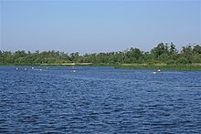
 Barton Broad Barton Broad | |
| Location | Norfolk |
|---|---|
| Grid reference | TG 365 215 |
| Interest | Biological |
| Area | 745.3 hectares (1,842 acres) |
| Notification | 1989 |
| Location map | Magic Map |
Ant Broads and Marshes is a 745.3-hectare (1,842-acre) biological Site of Special Scientific Interest north-east of Norwich in Norfolk. Most of it is a Nature Conservation Review site, Grade 1, and it is part of the Broadland Ramsar and Special Protection Area, and The Broads Special Area of Conservation. Part of it is the Barton Broad nature reserve, which is managed by the Norfolk Wildlife Trust, and two areas are National Nature Reserves.
This site in the valley of the River Ant is described by Natural England as the "finest example of unpolluted valley fen in Western Europe". It has a network of dykes that support a diverse variety of aquatic plants, and its fenland invertebrate fauna is of national importance.
References
- ^ "Designated Sites View: Ant Broads and Marshes". Sites of Special Scientific Interest. Natural England. Retrieved 6 June 2018.
- "Map of Ant Broads and Marshes". Sites of Special Scientific Interest. Natural England. Retrieved 6 June 2018.
- Ratcliffe, Derek, ed. (1977). A Nature Conservation Review. Vol. 2. Cambridge, UK: Cambridge University Press. pp. 214, 307. ISBN 0-521-21403-3.
- "Designated Sites View: Broadland". Ramsar Site. Natural England. Retrieved 25 May 2018.
- "Designated Sites View: Broadland". Special Protection Area. Natural England. Retrieved 25 May 2018.
- "Designated Sites View: The Broads". Special Area of Conservation. Natural England. Retrieved 25 May 2018.
- "Barton Broad". Norfolk Wildlife Trust. Retrieved 21 May 2018.
- "Designated Sites View: Ant Broads and Marshes". National Nature Reserves. Natural England. Retrieved 25 May 2018.
- "Designated Sites View: How Hill". National Nature Reserves. Natural England. Retrieved 5 June 2018.
- "Ant Broads and Marshes citation" (PDF). Sites of Special Scientific Interest. Natural England. Retrieved 6 June 2018.
52°44′20″N 1°30′07″E / 52.739°N 1.502°E / 52.739; 1.502
Categories: