| Site of Special Scientific Interest | |
 | |
| Location | Norfolk |
|---|---|
| Grid reference | TG 087 374 |
| Interest | Biological |
| Area | 49.9 hectares (123 acres) |
| Notification | 1986 |
| Location map | Magic Map |
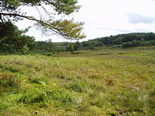
Holt Lowes is a 49.9-hectare (123-acre) biological Site of Special Scientific Interest west of Cromer in Norfolk. It is a Nature Conservation Review site, Grade 2, and part of the Norfolk Valley Fens Special Area of Conservation.
This site is mainly dry and sandy heath in the valley of the River Glaven, with a mire along a tributary which runs through the heath. Ground flora includes wood horsetail at its only known location in East Anglia.
The site is open to the public.
References
- ^ "Designated Sites View: Holt Lowes". Sites of Special Scientific Interest. Natural England. Retrieved 12 June 2018.
- "Map of Holt Lowes". Sites of Special Scientific Interest. Natural England. Retrieved 12 June 2018.
- Ratcliffe, Derek, ed. (1977). A Nature Conservation Review. Vol. 2. Cambridge, UK: Cambridge University Press. p. 140. ISBN 0521-21403-3.
- "Designated Sites View: Norfolk Valley Fens". Special Areas of Conservation. Natural England. Retrieved 25 May 2018.
- "Holt Lowes citation" (PDF). Sites of Special Scientific Interest. Natural England. Retrieved 12 June 2018.
52°53′38″N 1°06′04″E / 52.894°N 1.101°E / 52.894; 1.101
Category: