| Béchar Province ولاية بشار | |
|---|---|
| Province | |
 The desert in Béchar The desert in Béchar | |
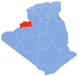
 Map of Algeria highlighting Béchar Map of Algeria highlighting Béchar | |
| Coordinates: 31°20′N 1°55′W / 31.333°N 1.917°W / 31.333; -1.917 | |
| Country | |
| Capital | Béchar |
| Government | |
| • Wāli | Mr. Mecheri Azzedine |
| Area | |
| • Total | 161,400 km (62,300 sq mi) |
| Elevation | 605 m (1,985 ft) |
| Population | |
| • Total | 274,866 |
| • Density | 1.7/km (4.4/sq mi) |
| Time zone | UTC+01 (CET) |
| Area Code | +213 (0) 29 |
| ISO 3166 code | DZ-08 |
| Districts | 12 |
| Municipalities | 21 |
Béchar (Arabic: ولاية بشار) is a province (wilaya) in Algeria, located on the border with Morocco in the Algerian Sahara. It is the second least-densely populated province in Algeria. Its capital and biggest city is Béchar.
History
The greater part of the province is dry plains (hamadas) suitable for grazing but with insufficient surface water to support agriculture. Most settlements are therefore concentrated in oases along the Saoura valley and its tributaries. Natural resources include coal deposits in the north around Bechar and Kenadsa.
The oases' traditional economic basis was agriculture, notably growing date palms and grain. The inhabitants of several oases, notably Ouakda, Lahmar and Boukais, speak Berber languages, while the rest speak Arabic and Korandje. Many of the oases had significant populations of shurfa or Haratin peoples. There is a notable zaouia (traditional religious school) at Kenadsa. The region also supported a substantial mainly Arab pastoralist nomadic population, notably the Doui-Menia and Ouled Djerir; most or all have settled in the oases.
Trans-Saharan trade routes passing through this region played an important role in its economy in pre-modern times, but have at present been superseded. A small tourism industry exists, focused particularly on Taghit. Béchar, whose growth from a minor village began only in the early 20th century, has become the principal urban and administrative centre.
The region has a distinctive musical scene influenced by sub-Saharan African rhythms, whose best known representative is the Gnawi singer Hasna El Becharia. Another locally well-known group is El Sed, from Kenadsa.
Disagreements between Morocco and Algeria over their mutual border in this province and Tindouf led to conflict after Algeria's independence, the so-called Sand War.
The province was created from the Saoura department in 1974. In 1984 Tindouf Province was carved out of its territory. In 2019 Béni Abbès Province followed.
Administrative divisions
The province is made up of 6 districts and 11 municipalities.
The districts are:
The municipalities are:
- Abadla
- Béchar
- Beni Ounif
- Boukais
- Erg Ferradj
- Kenadsa
- Lahmar
- Mechraa Houari Boumedienne
- Meridja
- Mogheul
- Taghit
References
- Office National des Statistiques, Recensement General de la Population et de l’Habitat 2008 Archived July 24, 2008, at the Wayback Machine Preliminary results of the 2008 population census. Accessed on 2008-07-02.
- "Mining Potentialities". Archived from the original on 2010-11-18. Retrieved 2010-09-19.
- "Dairas Et Communes" (in French). Site Officiel de la Wilaya de Bechar. Archived from the original on 16 February 2013. Retrieved 9 March 2013.
| Capital: Béchar | ||
| Béchar District |  | |
| Abadla District | ||
| Béni Abbès District | ||
| Béni Ounif District | ||
| El Ouata District | ||
| Igli District | ||
| Kénadsa District | ||
| Kerzaz District | ||
| Lahmar District | ||
| Ouled Khodeïr District | ||
| Tabelbala District | ||
| Taghit District | ||
| ||
