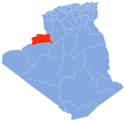
| Timgharine | |
|---|---|
| Village | |
 | |
| Coordinates: 29°9′49″N 1°2′46″W / 29.16361°N 1.04611°W / 29.16361; -1.04611 | |
| Country | |
| Province | Béchar Province |
| District | Ouled Khoudir District |
| Commune | Ksabi |
| Elevation | 356 m (1,168 ft) |
| Time zone | UTC+1 (CET) |
Timgharine (also written Timrharine) is a village in the commune of Ksabi, in Ouled Khoudir District, Béchar Province, Algeria. The village is located on the east bank of the Oued Saoura about halfway between Ouled Khoudir to the north and Ksabi to the south. It is connected to Ouled Khoudir by a local road along the side of the river, and to the N6 national highway by a road across the river to the west.
References
- ^ "Décret n° 84-365, fixant la composition, la consistance et les limites territoriale des communes. Wilaya d'El Oued" (PDF) (in French). Journal officiel de la République Algérienne. 19 December 1984. p. 1490. Archived from the original (PDF) on 2011-07-31. Retrieved 2 March 2013.
- "Timrharine, Algeria". Geonames.Org. Retrieved 9 May 2013.
| Places adjacent to Timgharine | ||||||||||||||||
|---|---|---|---|---|---|---|---|---|---|---|---|---|---|---|---|---|
| ||||||||||||||||
| Capital: Béchar | ||
| Béchar District |  | |
| Abadla District | ||
| Béni Abbès District | ||
| Béni Ounif District | ||
| El Ouata District | ||
| Igli District | ||
| Kénadsa District | ||
| Kerzaz District | ||
| Lahmar District | ||
| Ouled Khodeïr District | ||
| Tabelbala District | ||
| Taghit District | ||
This article about a location in Béchar Province is a stub. You can help Misplaced Pages by expanding it. |