| Bolnisi Municipality ბოლნისის მუნიციპალიტეტი | |
|---|---|
 Mosque in lower Bolnisi Mosque in lower Bolnisi | |
 Flag Flag Seal Seal | |
 | |
| Country | |
| Mkhare | Kvemo Kartli |
| Administrative centre | Bolnisi |
| Government | |
| • Type | Mayor–Council |
| • Body | Bolnisi Municipal Assembly |
| • Mayor | David Sherazadishvili (GD) |
| Area | |
| • Total | 804 km (310 sq mi) |
| Population | |
| • Total | 56,036 |
| • Density | 70/km (180/sq mi) |
| Population by ethnicity | |
| • Azerbaijanis | 63.4 % |
| • Georgians | 30.9 % |
| • Armenians | 5.0 % |
| Time zone | Georgian Time |
| Website | http://bolnisi.gov.ge/ |
Bolnisi (Georgian: ბოლნისის მუნიციპალიტეტი, Bolnisis munitsip’alit’et’i) is a municipality in Georgia's southern region of Kvemo Kartli, covering an area of 804 km (310 sq mi). As of 2021 it had a population of 56,036 people. The city of Bolnisi is its administrative centre.
Geographical location
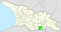
Bolnisi Municipality is situated in the south of the country and shares a border with Armenia. The highest point is Mt Loki at 2,142 m (7,028 ft) above sea level.
Administrative divisions
Bolnisi municipality is administratively divided into 14 communities (თემი, temi) with 46 villages (სოფელი, sopeli), two urban-type settlements (დაბა, daba) and one city (ქალაკი, kalaki).
Population
The population of Bolnisi was 56,036 at the beginning of 2021, which is an increase of nearly 5% since the last census of 2014. In 2014 the ethnic composition was 63.4% Azerbaijani, 30.9% Georgian and 5.0% Armenian. The population density is 69.7 people per square kilometer (2021).
| Population Bolnisi Municipality | ||||||||||||||||||
|---|---|---|---|---|---|---|---|---|---|---|---|---|---|---|---|---|---|---|
| 1897 | 1922 | 1926 | 1939 | 1959 | 1970 | 1979 | 1989 | 2002 | 2014 | 2021 | ||||||||
| Bolnisi Municipality | - | - | - | 33,975 | ||||||||||||||
| Bolnisi | - | 4,591 | ||||||||||||||||
| Kazreti (daba) | - | - | - | - | - | 2,538 | ||||||||||||
| Tamarisi (daba) | - | - | - | - | - | - | - | 707 | ||||||||||
| Data: Population statistics Georgia 1897 to present. Note: | ||||||||||||||||||
Politics

Bolnisi Municipal Assembly (Georgian: ბოლნისის საკრებულო) is the representative body in Bolnisi Municipality, consisting of 36 members which are elected every four years. The last election was held in October 2021. David Sherazadishvili of Georgian Dream was reelected as mayor.
| Party | 2017 | 2021 | Current Municipal Assembly | |||||||||||||||||||||||||||||||||||||||||||||
|---|---|---|---|---|---|---|---|---|---|---|---|---|---|---|---|---|---|---|---|---|---|---|---|---|---|---|---|---|---|---|---|---|---|---|---|---|---|---|---|---|---|---|---|---|---|---|---|---|
| Georgian Dream | 28 | 30 | ||||||||||||||||||||||||||||||||||||||||||||||
| United National Movement | 2 | 6 | ||||||||||||||||||||||||||||||||||||||||||||||
| Total | 30 | 36 | ||||||||||||||||||||||||||||||||||||||||||||||
See also
External links
References
- ^ "Population and Demography - Population by cities and boroughs (daba), as of 1 January". National Statistics Office of Georgia, Geostat. 2021-01-01. Retrieved 2022-03-08.
- "Ethnic composition of Georgia 2014". mashke.org. Archived from the original on 2018-11-04.
- ^ "Main Results of the 2014 Census (Publication)" (PDF). Census.ge, National Statistics Office of Georgia (Geostat) (in Georgian). 2016-04-28. pp. 318–322. Archived from the original (PDF) on 2020-02-13. Retrieved 2022-03-08.
- Tielidze, Levan; Gobejishvili, Ramin (2019). "13 Achara-Trialeti-Loki Mountainous Terrain". Geomorphology of Georgia. Springer. pp. 238–239. doi:10.1007/978-3-319-77764-1. ISBN 978-3-319-77764-1. S2CID 199491923. Retrieved 2022-03-08.
- ^ The 2014 census found an inexplicable gap with the data from the national statistical office Geostat. UN-assisted research has found the 2002 census was inflated by about 8-9 percent. See, "1. Introduction", Page 1.
- Until 1921 called Katharinenfeld, between 1921-1943 called Luxemburg.
- "Population divisions of Georgia". Population Statistics Eastern Europe and former USSR. Retrieved 2022-03-06.
- "Population cities & towns of Georgia". Population Statistics Eastern Europe and former USSR. Retrieved 2022-03-06.
- "Ethnic composition rural Georgia 1923". Population Statistics Eastern Europe and former USSR. Retrieved 2022-03-06.
- "Population Dynamics in Georgia - An Overview Based on the 2014 General Population Census Data" (PDF). National Statistics Office of Georgia, Geostat. 2017-11-29. Retrieved 2022-03-06.
- "Protocol elected municipal council members and mayors 2017" (PDF) (in Georgian). CESKO Central Election Commission. pp. 21–22. Retrieved 2022-03-03.
- "Protocol elected municipal council members and mayors 2021" (PDF) (in Georgian). CESKO Central Election Commission. pp. 27–29. Retrieved 2022-03-03.
41°27′00″N 44°32′00″E / 41.4500°N 44.5333°E / 41.4500; 44.5333
This Georgia location article is a stub. You can help Misplaced Pages by expanding it. |