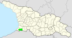
| Keda Municipality ქედის მუნიციპალიტეტი | |
|---|---|
 The Acharistsqali river, which flows through Keda The Acharistsqali river, which flows through Keda | |
 Flag Flag Seal Seal | |
 | |
| Country | |
| Autonomous Republic | Adjara |
| Administrative centre | Keda |
| Government | |
| • Mayor | Roland Beridze (GD) |
| Area | |
| • Total | 452 km (175 sq mi) |
| Population | |
| • Total | 16,700 |
| • Density | 37/km (96/sq mi) |
| Time zone | UTC+4 (Georgian Time) |
| Website | keda.gov.ge |
Keda (Georgian: ქედის მუნიციპალიტეტი), Keda Municiṕaliťeťi) is a municipality in Georgia's southwestern autonomous republic of Adjara with a population of 16,700 people (2021). It covers an area of 452 km (175 sq mi) and the daba ('Urban-type settlement') Keda is its administrative centre.
Historical monuments in the municipality include the medieval Orthodox churches at Makhuntseti, Zesopeli, and Namonastrevi, and the bridges of Tsoniarisi and Dandalo.
Geography
Keda borders the municipalities of Khelvachauri to the south and west, Kobuleti to the northwest and Shuakhevi to the east. The municipality also has a 17 kilometer long border with Turkey in the south, where the Shavsheti Range forms the natural border. The Meskheti Range forms the municipality's northwestern border with Kobuleti. Adjara's main river, the Acharistsqali (literally "river of Adjara") flows for 42 kilometres (26 mi) from east to west through Keda. The river gorge has a Mediterranean subtropical climate. As the elevation increases, the climate becomes humid, with annual rainfall of around 1500mm per year, providing green vegetation.
The total area of the municipality is 452 km (175 sq mi). The administrative center of Keda is located on the bank of the Acharistsqali at an altitude of 256 metres (840 ft) above sea level, while Mount Ghoma at 2,441 metres (8,009 ft) is the highest point, located near the border with Turkey.
Administrative divisions
Keda Municipality is administratively divided into 10 communities (თემი, temi) with 63 villages (სოფელი, sopeli). There is one urban-type settlement (დაბა, daba), the municipal centre Keda.
Population
The population of Keda Municipality is 16,700 according to the 2021 estimate, which is a minimal decrease compared to the last census of 2014. The municipal center of Keda has experienced a relatively significant population decline since 2014, dropping from 1,510 to 1,285 residents in 2021. The population density is 36.9 people per square kilometer.
According to the 2014 census, the population of Keda consisted for 62% of Muslim Georgians, followed by Georgians belonging to the Georgian Orthodox Church (31%). There are no significant ethnic minorities.
| Population Keda Municipality | ||||||||||||||||||
|---|---|---|---|---|---|---|---|---|---|---|---|---|---|---|---|---|---|---|
| 1923 | 1939 | 1959 | 1970 | 1979 | 1989 | 2002 | 2014 | 2021 | ||||||||||
| Keda Municipality | - | 13,392 | ||||||||||||||||
| Keda (daba) | 124 | |||||||||||||||||
| Data: Population statistics Georgia 1897 to present. Note: | ||||||||||||||||||
Politics

The Keda Municipal Assembly (Georgian: ქედის საკრებულო, Keda Sakrebulo) is a representative body in Keda Municipality consisting of 21 members, elected every four years. The last election was held in October 2021. Roland Beridze of the Georgian Dream party was elected mayor.
| Party | 2017 | 2021 | Current Municipal Assembly | |||||||||||||||||||||||||||||||||||||||||||||
|---|---|---|---|---|---|---|---|---|---|---|---|---|---|---|---|---|---|---|---|---|---|---|---|---|---|---|---|---|---|---|---|---|---|---|---|---|---|---|---|---|---|---|---|---|---|---|---|---|
| Georgian Dream | 18 | 15 | ||||||||||||||||||||||||||||||||||||||||||||||
| United National Movement | 3 | 4 | ||||||||||||||||||||||||||||||||||||||||||||||
| For Georgia | 1 | |||||||||||||||||||||||||||||||||||||||||||||||
| Lelo | 1 | |||||||||||||||||||||||||||||||||||||||||||||||
| Alliance of Patriots | 2 | |||||||||||||||||||||||||||||||||||||||||||||||
| European Georgia | 1 | |||||||||||||||||||||||||||||||||||||||||||||||
| Total | 24 | 21 | ||||||||||||||||||||||||||||||||||||||||||||||
See also
References
- ^ "Main Results of the 2014 Census (Publication)" (PDF). Census.ge, National Statistics Office of Georgia (Geostat) (in Georgian). 2016-04-28. pp. 20–24. Archived from the original (PDF) on 2020-02-13. Retrieved 2022-04-20.
- ^ "Population and Demography - Population by cities and boroughs (daba), as of 1 January". National Statistics Office of Georgia, Geostat. 2021-01-01. Retrieved 2022-04-20.
- "Keda". Georgian Travel Guide. Retrieved 2022-04-20.
- ^ The 2014 census found an inexplicable gap with the data from the national statistical office Geostat. UN-assisted research has found the 2002 census was inflated by about 8-9 percent. See, "1. Introduction", Page 1.
- "Population divisions of Georgia". Population Statistics Eastern Europe and former USSR. Retrieved 2022-03-06.
- "Population cities & towns of Georgia". Population Statistics Eastern Europe and former USSR. Retrieved 2022-03-06.
- "Ethnic Composition of Rural georgia in 1923". Population Statistics Eastern Europe and former USSR. Retrieved 2022-04-20.
- "1939, Keda District". Ethno Kavkaz (in Russian). Retrieved 2022-04-20.
- "Population Dynamics in Georgia - An Overview Based on the 2014 General Population Census Data" (PDF). National Statistics Office of Georgia, Geostat. 2017-11-29. Retrieved 2022-03-06.
- "Protocol elected municipal council members and mayors 2017" (PDF) (in Georgian). CESKO Central Election Commission. p. 94-95. Retrieved 2021-01-06.
- "Protocol elected municipal council members and mayors 2021" (PDF) (in Georgian). CESKO Central Election Commission. p. 116-117. Retrieved 2021-01-06.
41°34′N 41°57′E / 41.567°N 41.950°E / 41.567; 41.950
This Georgia location article is a stub. You can help Misplaced Pages by expanding it. |