You can help expand this article with text translated from the corresponding article in Spanish. Click for important translation instructions.
|
| Circuito de Playas | |
 | |
| From | Avenida Santa Rosa |
|---|---|
| To | Club Regatas |
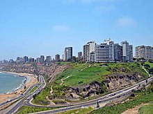
The Circuito de playas de la Costa Verde, also simply the Costa Verde, is a highway located along the coast of Callao and Lima, Peru. It unites the districts of La Punta, La Perla, San Miguel, Magdalena del Mar, San Isidro, Miraflores, Barranco and Chorrillos.
History
The land where the road is currently located was originally the location of large cliffs with no road access. Before the construction of the highway, some roads and balnearios had preceded the project under the second government of Augusto B. Leguía.
The land was reclaimed to make way for the project using land dug up from the construction of the Paseo de la República, an idea by then mayor of Miraflores Ernesto Aramburú Menchaca [es]. The Costa Verde project began and ended in the 1970s, with its name coming from a part of the plan that included adding vegetation to the then bare cliffs.
In 1983, La Rosa Náutica, a seaside restaurant, was built on one of the jetties next to the road circuit.
During the 2007 Peru earthquake, the highway was damaged and temporarily closed.
The Costa Verde-San Miguel Park was inaugurated in 2019 to be used in the Pan American Games, as well as the Parapan American Games.
See also
References
- ^ García, Oscar (2020-01-07). "La historia de la Costa Verde y de la ciudad que conquistó su mar". Somos.
- ^ "Costa Verde: ¿cómo lucía hace 100 años el espacio donde se construyó el circuito de playas?". La República. 2022-09-05.
- Chávez, Renzo (2020-01-31). "La Costa Verde en la historia". El Peruano.
- "Accesos a Circuito de Playas de Costa Verde continúan cerrados al tránsito vehicular". Andina. 2007-08-16. Archived from the original on 2007-09-27.
- "San Miguel será sede de cinco disciplinas de los Panamericanos 2019". América Noticias. 2017-05-12.