Misplaced Pages

County of Mackenzie

Article snapshot taken from Wikipedia with creative commons attribution-sharealike license. Give it a read and then ask your questions in the chat. We can research this topic together.

For the specialized municipality in Alberta, Canada, see Mackenzie County.

Cadastral in Queensland, Australia
Mackenzie
Queensland
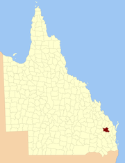
Location within Queensland
Lands administrative divisions around Mackenzie:
Wicklow Bowen Cook
Newcastle Mackenzie Lennox
Boondooma Fitzroy Lennox
Map all coordinates using OpenStreetMap

Download coordinates as:

The County of Mackenzie is a county (a cadastral division) in Queensland, Australia, located in the Wide Bay–Burnett region. It was named after Robert Ramsay Mackenzie, who served as Premier of Queensland in 1867–1868 and was also member for Burnett, it was formally named and bounded by the Governor in Council on 7 March 1901 under the Land Act 1897.

Parishes

Mackenzie is divided into parishes, as listed below:

Parish LGA Coordinates Towns
Aranbanga North Burnett 25°47′S 151°35′E / 25.783°S 151.583°E / -25.783; 151.583 (Aranbanga Parish)
Ban Ban North Burnett 25°46′S 151°54′E / 25.767°S 151.900°E / -25.767; 151.900 (Ban Ban Parish)
Barabara North Burnett 25°50′S 151°25′E / 25.833°S 151.417°E / -25.833; 151.417 (Barabara Parish)
Beninbi South Burnett 25°55′S 151°41′E / 25.917°S 151.683°E / -25.917; 151.683 (Beninbi Parish)
Boonara Gympie 26°03′S 152°04′E / 26.050°S 152.067°E / -26.050; 152.067 (Boonara Parish)
Boonimba Gympie 25°52′S 151°50′E / 25.867°S 151.833°E / -25.867; 151.833 (Boonimba Parish)
Booubyjan Gympie 25°54′S 151°59′E / 25.900°S 151.983°E / -25.900; 151.983 (Booubyjan Parish) Booubyjan
Dundar North Burnett 25°40′S 151°54′E / 25.667°S 151.900°E / -25.667; 151.900 (Dundar Parish) Coalstoun Lakes
Gayndah North Burnett 25°40′S 151°35′E / 25.667°S 151.583°E / -25.667; 151.583 (Gayndah Parish) Gayndah (S)
Ginoondan North Burnett 25°34′S 151°43′E / 25.567°S 151.717°E / -25.567; 151.717 (Ginoondan Parish) Wetheron
Gooroolballin North Burnett 25°34′S 151°50′E / 25.567°S 151.833°E / -25.567; 151.833 (Gooroolballin Parish) Gooroolba, Byrnestown
Grongah Gympie 25°57′S 152°08′E / 25.950°S 152.133°E / -25.950; 152.133 (Grongah Parish)
Johngboon North Burnett 25°48′S 151°42′E / 25.800°S 151.700°E / -25.800; 151.700 (Johngboon Parish)
Kinellan North Burnett 25°42′S 151°43′E / 25.700°S 151.717°E / -25.700; 151.717 (Kinellan Parish)
Malmaison North Burnett 25°44′S 151°26′E / 25.733°S 151.433°E / -25.733; 151.433 (Malmaison Parish)
Mundubbera North Burnett 25°39′S 151°21′E / 25.650°S 151.350°E / -25.650; 151.350 (Mundubbera Parish) Boynewood
Nangur Gympie 26°06′S 152°01′E / 26.100°S 152.017°E / -26.100; 152.017 (Nangur Parish)
Toondahra North Burnett 25°56′S 151°26′E / 25.933°S 151.433°E / -25.933; 151.433 (Toondahra Parish)
Wigton South Burnett 25°59′S 151°34′E / 25.983°S 151.567°E / -25.983; 151.567 (Wigton Parish)
Windera South Burnett 26°02′S 151°52′E / 26.033°S 151.867°E / -26.033; 151.867 (Windera Parish) Windera
Woroon South Burnett 26°04′S 151°43′E / 26.067°S 151.717°E / -26.067; 151.717 (Woroon Parish)

References

  1. "Mackenzie (entry 20442)". Queensland Place Names. Queensland Government. Retrieved 8 September 2015.
  2. Wide Bay/Burnett Districts, County of Mackenzie Maps – D7 Series at Queensland Archives.

25°38′S 151°37′E / 25.633°S 151.617°E / -25.633; 151.617External links

Category: