Town in Georgia, United States
| Deepstep, Georgia | |
|---|---|
| Town | |
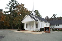
 United Methodist Church United Methodist Church | |
 Location in Washington County and the state of Georgia Location in Washington County and the state of Georgia | |
| Coordinates: 33°1′19″N 82°58′6″W / 33.02194°N 82.96833°W / 33.02194; -82.96833 | |
| Country | United States |
| State | Georgia |
| County | Washington |
| Government | |
| • Type | Mayor-council government |
| • Mayor | Randall Veal |
| • Deepstep City Council |
Members
|
| Area | |
| • Total | 0.88 sq mi (2.29 km) |
| • Land | 0.82 sq mi (2.11 km) |
| • Water | 0.07 sq mi (0.18 km) |
| Elevation | 312 ft (95 m) |
| Population | |
| • Total | 117 |
| • Density | 143.38/sq mi (55.38/km) |
| Time zone | UTC-5 (Eastern (EST)) |
| • Summer (DST) | UTC-4 (EDT) |
| ZIP code | 31082 |
| Area code | 478 |
| FIPS code | 13-22108 |
| GNIS feature ID | 0331534 |
Deepstep is a town in Washington County, Georgia, United States. The population was 117 in 2020.
History
A post office called Deepstep was established in 1886. The Georgia General Assembly incorporated the place in 1900 as the "Town of Deepstep". The town is named after Deepstep Creek.
Geography
Deepstep is located at 33°1′19″N 82°58′6″W / 33.02194°N 82.96833°W / 33.02194; -82.96833 (33.021827, -82.968337). According to the United States Census Bureau, the town has a total area of 0.8 square miles (2.1 km), of which 0.8 square miles (2.1 km) is land and 0.04 square miles (0.10 km) (2.53%) is water.
Demographics
| Census | Pop. | Note | %± |
|---|---|---|---|
| 1910 | 149 | — | |
| 1920 | 184 | 23.5% | |
| 1930 | 180 | −2.2% | |
| 1940 | 174 | −3.3% | |
| 1950 | 159 | −8.6% | |
| 1960 | 139 | −12.6% | |
| 1970 | 107 | −23.0% | |
| 1980 | 120 | 12.1% | |
| 1990 | 111 | −7.5% | |
| 2000 | 132 | 18.9% | |
| 2010 | 131 | −0.8% | |
| 2020 | 117 | −10.7% | |
| U.S. Decennial Census | |||
As of the census of 2000, there were 132 people, 54 households, and 40 families residing in the town. By 2020, its population was 117.
See also
References
- "DEEPSTEP". Georgia Municipal Association. Retrieved December 18, 2024.
- "2020 U.S. Gazetteer Files". United States Census Bureau. Retrieved December 18, 2021.
- ^ "U.S. Census website". United States Census Bureau. Retrieved January 31, 2008.
- "US Board on Geographic Names". United States Geological Survey. October 25, 2007. Retrieved January 31, 2008.
- "Post Offices". Jim Forte Postal History. Retrieved April 19, 2018.
- Acts Passed by the General Assembly of Georgia. J. Johnston. 1900. p. 279.
- Krakow, Kenneth K. (1975). Georgia Place-Names: Their History and Origins (PDF). Macon, GA: Winship Press. p. 60. ISBN 0-915430-00-2.
- "US Gazetteer files: 2010, 2000, and 1990". United States Census Bureau. February 12, 2011. Retrieved April 23, 2011.
- "Census of Population and Housing". Census.gov. Retrieved June 4, 2015.
| Municipalities and communities of Washington County, Georgia, United States | ||
|---|---|---|
| County seat: Sandersville | ||
| Cities |  | |
| Towns | ||
| CDP | ||
| Other unincorporated communities | ||
| Central Savannah River Area (CSRA) | |
|---|---|
| Central Savannah River Area of Georgia and South Carolina | |