City in Georgia, United States
| Oconee, Georgia | |
|---|---|
| City | |
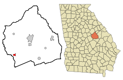
 Location in Washington County and the state of Georgia Location in Washington County and the state of Georgia | |
| Coordinates: 32°51′23″N 82°57′16″W / 32.85639°N 82.95444°W / 32.85639; -82.95444 | |
| Country | United States |
| State | Georgia |
| County | Washington |
| Area | |
| • Total | 1.30 sq mi (3.36 km) |
| • Land | 1.30 sq mi (3.36 km) |
| • Water | 0.00 sq mi (0.00 km) |
| Elevation | 230 ft (70 m) |
| Population | |
| • Total | 197 |
| • Density | 151.77/sq mi (58.60/km) |
| Time zone | UTC-5 (Eastern (EST)) |
| • Summer (DST) | UTC-4 (EDT) |
| ZIP code | 31067 |
| Area code | 478 |
| FIPS code | 13-57456 |
| GNIS feature ID | 0332556 |
Oconee is a city in Washington County, Georgia, United States. The population was 197 in 2020.
History
The city's name derives from the Oconee, a Hitchiti-speaking tribe who inhabited central Georgia from 1692 until 1715. The Oconee lived in present-day Baldwin County, Georgia at a settlement known as Oconee Old Town, later moving to the Chattahoochee River in the early 18th century. The name exists in several variations, including Ocone, Oconi, Ocony, and Ekwoni.
The city of Oconee was named after the river that bears the tribe's name. It was founded in the early 1840s, when the railroad was extended to that point.
The Georgia General Assembly incorporated Oconee as a town in 1876.
Notable natives
- Berry Gordy Sr. and wife, Bertha Fuller Gordy, the parents of legendary music producer and Motown founder Berry Gordy Jr., left Oconee in 1922.
Geography
Oconee is located at 32°51′23″N 82°57′16″W / 32.85639°N 82.95444°W / 32.85639; -82.95444 (32.856310, -82.954316). According to the United States Census Bureau, the city has a total area of 1.1 square miles (2.8 km), all land.
Demographics
| Census | Pop. | Note | %± |
|---|---|---|---|
| 1970 | 262 | — | |
| 1980 | 306 | 16.8% | |
| 1990 | 234 | −23.5% | |
| 2000 | 280 | 19.7% | |
| 2010 | 252 | −10.0% | |
| 2020 | 197 | −21.8% | |
| U.S. Decennial Census | |||
As of the census of 2000, there were 280 people, 94 households, and 67 families living in the city. By 2020, its population was 197.
See also
References
- "2020 U.S. Gazetteer Files". United States Census Bureau. Retrieved December 18, 2021.
- ^ "U.S. Census website". United States Census Bureau. Retrieved January 31, 2008.
- "US Board on Geographic Names". United States Geological Survey. October 25, 2007. Retrieved January 31, 2008.
- Krakow, Kenneth K. (1999). Georgia Place-names (PDF). Macon, GA.: Winship Press. pp. 163–164. ISBN 0-915430-00-2.
- Krakow, Kenneth K. (1975). Georgia Place-Names: Their History and Origins (PDF). Macon, GA: Winship Press. p. 162. ISBN 0-915430-00-2.
- Acts Passed by the General Assembly of Georgia. J. Johnston. 1876. p. 151.
- "US Gazetteer files: 2010, 2000, and 1990". United States Census Bureau. February 12, 2011. Retrieved April 23, 2011.
- "Census of Population and Housing". Census.gov. Retrieved June 4, 2015.
| Municipalities and communities of Washington County, Georgia, United States | ||
|---|---|---|
| County seat: Sandersville | ||
| Cities |  | |
| Towns | ||
| CDP | ||
| Other unincorporated communities | ||
| Central Savannah River Area (CSRA) | |
|---|---|
| Central Savannah River Area of Georgia and South Carolina | |