| This article needs additional citations for verification. Please help improve this article by adding citations to reliable sources. Unsourced material may be challenged and removed. Find sources: "Hamra, Beirut" – news · newspapers · books · scholar · JSTOR (January 2023) (Learn how and when to remove this message) |
| Hamra الحمراء | |
|---|---|
| Neighborhood | |
 | |
 | |
| Coordinates: 33°54′N 35°29′E / 33.900°N 35.483°E / 33.900; 35.483 | |
| Country | |
| Governorate | Beirut Governorate |
| District | Beirut District |
| Government | |
| • Municipality | Beirut Municipality |
| Highest elevation | 50 m (160 ft) |
| Lowest elevation | 25 m (82 ft) |
| Time zone | UTC+2 (EET) |
| • Summer (DST) | UTC+3 (EEST) |
| Dialing code | +961 |
| Website | beirut.gov.lb |
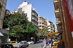
Hamra (Arabic: الحمراء Al-Hamra') is a neighborhood (sector 34) in Beirut, Lebanon (quarter Ras Beirut). The heart of the neighborhood, Hamra Street, is a major commercial district, and is known for its fashion stores, restaurants, cafes, bars and hotels, and a lively nightlife.
The American University of Beirut and Lebanese American University are in the neighborhood.
Hamra Street used to be one of the main places where Arab poets, writers, thinkers, and philosophers met and collaborated, making it an important cultural hub. Many impacts of the Lebanese Civil War remain on the walls, but it has also seen development. Although it may not be as culturally and artistically vibrant as before, it remains rich with life and art. Graffiti has become a form of artistic expression along the central boulevard; an example is a mural of the popular singer and icon Sabah towards the beginning of the street.
References
- "Campus & Facilities". American University of Beirut. Retrieved 6 January 2023.
- "Faculty of Public Health". Lebanese University. Retrieved 6 January 2023.
- Ellie Violet Bramley (22 September 2015). "How a Beirut graffiti artist is using his murals to try to unite a fragmented city". The Guardian. Retrieved 6 January 2023.
| Beirut Neighbourhoods (a.k.a. cadastres, quarters), Numbered Sectors, and Streets | |
|---|---|
| Aain (Dar) el-Mraisse دار الِمْريسِة |
|
| Ras Beirut رأس بيروت |
|
| Mousaitbeh الِمْصَيطْبِِة |
|
| Zuqaq al-Blat زْقاق الِبْلاط |
|
| Mina el-Hosn ميناء الحُصن |
|
| Marfa'a المَرْفَأ |
|
| Bachoura الباشورَة |
|
| Mazraa المَزْرَعَة |
|
| Achrafieh الأَشْرَفِيِّة |
|
| Saifi الصَّيْفي |
|
| Rmeil neighbourhood الرّميل |
|
| Medawar الِمْدَوَّر |
|