33°53′32″N 35°29′54″E / 33.89222°N 35.49833°E / 33.89222; 35.49833

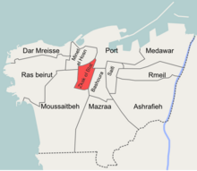
Zuqaq al-Blat (Arabic: زقاق البلاط) is one of the twelve quarters of Beirut.
Etymology
Zuqaq al-Blat literally means "the cobbled alley", this was a colloquial name given to the street extending from the old city to the Qantari hill and which was covered with cobblestones in the 19th century.
Zuqaq al-Blat is also commonly called "al-Batrakieh" (Arabic: البطركية, the Patriarchate) due to the presence of the seat of the Greek Catholic Patriarchate of Beirut within its borders.
History
Once a medieval walled port town, Beirut experienced rapid growth during the second half of the 19th century; the overcrowded city developed beyond its walls and the affluent citizens started to build their villas on the slopes of the surrounding hills, namely Ashrafieh, Qnatari and Musaytbeh.
In 1832 Beirut came under the occupation of Ibrahim Pasha's troops. The new Egyptian authorities undertook grand works of urban planning and sanitation. The appointed Egyptian-Circassian governor of Beirut, Mahmoud Na'ami Bey commissioned street cobbling works which stretched beyond the city's walls, the street extending from the south-western side of the city wall into the new extramural neighborhoods on the Qantari hill came to be known as Zuqaq al-Blat and gave its name to the quarter.
Notable residents
Some of the notable people resided in Zuqaq al-Blat included:
- Abd el-Qader Qabbani
- Butrus Bustani
- Fairuz
- Hussein Beyhum
- Khalil Sarkis
- Charles de Gaulle
- Omar Zaani
References
- Hanssen, Jens (2005). Fin de Siècle Beirut: The Making of an Ottoman Provincial Capital. Oxford University Press. ISBN 0199281637. Archived from the original on 2023-08-17. Retrieved 2020-10-04.
- ^ Kassir, Samir (2006). تاريخ بيروت (in Arabic). Beirut: Dar An-Nahar. ISBN 9953741018.
- زقاق البلاط (in Arabic). yabeyrouth.com. Archived from the original on October 22, 2012. Retrieved February 14, 2013.
- Kihtir Öztürk, Pelin (September 2006). Urban transformation of Ottoman port cities in the nineteenth century: Change from Ottoman Beirut to French mandatory Beirut (PDF) (MA thesis). Middle East Technical University. Archived (PDF) from the original on 2014-02-02. Retrieved 2013-02-14.
- Kassir, Samir; M. B. DeBevoise (2010). Beirut. University of California Press. ISBN 978-0520256682.
- ^ Speidl, Bianka (2011). "Distance in vicinity: Beirut's Zuqaq el-Blat, a place of transformation, conflict and co-existence". Études sur la Région Méditerranéenne. 20: 37. Archived from the original on 2023-04-29. Retrieved 2023-04-29.
- https://www.lorientlejour.com/article/1417567/les-annees-libanaises-de-charles-de-gaulle.html
| Beirut Neighbourhoods (a.k.a. cadastres, quarters), Numbered Sectors, and Streets | |
|---|---|
| Aain (Dar) el-Mraisse دار الِمْريسِة |
|
| Ras Beirut رأس بيروت |
|
| Mousaitbeh الِمْصَيطْبِِة |
|
| Zuqaq al-Blat زْقاق الِبْلاط |
|
| Mina el-Hosn ميناء الحُصن |
|
| Marfa'a المَرْفَأ |
|
| Bachoura الباشورَة |
|
| Mazraa المَزْرَعَة |
|
| Achrafieh الأَشْرَفِيِّة |
|
| Saifi الصَّيْفي |
|
| Rmeil neighbourhood الرّميل |
|
| Medawar الِمْدَوَّر |
|