| Huacshash | |
|---|---|
| Huaqshash | |
 | |
| Highest point | |
| Elevation | 5,644 m (18,517 ft) |
| Listing | List of mountains in Peru |
| Coordinates | 10°24′50″S 76°58′30″W / 10.41389°S 76.97500°W / -10.41389; -76.97500 |
| Naming | |
| Language of name | Quechua |
| Geography | |
 | |
| Location | Peru, Lima Region |
| Parent range | Andes, Huayhuash |
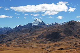
Huacshash or Huaqshash (possibly from local Quechua waqsa, meaning eye tooth) is a mountain in the west of the Huayhuash mountain range in the Andes of Peru, about 5,644 metres (18,517 ft) high. It is located in the Lima Region, Cajatambo Province, Cajatambo District. Huacshash lies on a sub-range in the west, south of the Huayllapa River, north of the Pumarinri River and southeast of the villages of Huayllapa and Auquimarca.
References
- ^ Neate, Jill (1994). "Peru". Mountaineering in the Andes (PDF). RGS-IBG Expedition Advisory Centre. p. 25. ISBN 0-907649-64-5.
- ^ Peru 1:100 000, Yanahuanca (21-j). IGN (Instituto Geográfico Nacional - Perú).
Huacshah
- ^ Díaz, Felipe (2008–2009). Carta Turística. Cordilleras Blanca, Negra, Huayhuash y Callejón de Huaylas. Archived from the original on 2016-03-03. Retrieved 2013-12-28.
- Teofilo Laime Ajacopa (2007). Diccionario Bilingüe: Iskay simipi yuyayk’anch: Quechua – Castellano / Castellano – Quechua (PDF). La Paz, Bolivia: futatraw.ourproject.org.
- escale.minedu.gob.pe UGEL map of the Cajatambo Province (Lima Region)]
This Lima Region geography article is a stub. You can help Misplaced Pages by expanding it. |