| Ikelenge District | |
|---|---|
| District | |
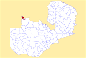
 District location in Zambia District location in Zambia | |
| Country | |
| Province | North-Western Province |
| Area | |
| • Total | 2,219.9 km (857.1 sq mi) |
| Population | |
| • Total | 44,775 |
| • Density | 20/km (52/sq mi) |
| Time zone | UTC+2 (CAT) |
Ikelenge District is a district of North-Western Province, Zambia. It was separated from Mwinilunga District in 2011. As of the 2022 Zambian Census, the district had a population of 44,775 people.
Ikelenge District is located north of Mwinilunga and contains the Kalene Hills together with the source of the Zambezi River and the Zengamina Hydroelectric Power Plant within its small area. The Zengamina Plant exists primarily because Zambia's national electricity grid does not reach the region.
The main road in the region is the T5 road, which connects Ikelenge to Mwinilunga in the south and to a border with Angola west of Kalene Hill.
References
- "Districts of Zambia". Statoids. Retrieved December 30, 2018.
- "Zambia: Administrative Division". citypopulation. Retrieved December 30, 2018.
- "Zambia : State steps into Ikelenge Boma wrangle". 2011-05-25. Retrieved 2022-10-08.
- "Zambia : Ikeleng'i upgrade cheers residents". 2011-03-21. Retrieved 2022-10-08.
- 2022 Census of Population and Housing - Preliminary Report (PDF)
- https://www.znbc.co.zm/news/ikelenge-dc-calls-for-investments/.
{{cite web}}: Missing or empty|title=(help) - "Zengamina Hydro Project | North West Zambia Development Trust". Archived from the original on 2022-04-23. Retrieved 2022-08-06.
- "Roads and Road Traffic Act | National Assembly of Zambia". www.parliament.gov.zm. Retrieved 2022-06-27.
| Central Province | |
|---|---|
| Copperbelt Province | |
| Eastern Province | |
| Luapula Province | |
| Lusaka Province | |
| Muchinga Province | |
| Northern Province | |
| North-Western Province | |
| Southern Province | |
| Western Province | |
11°14′S 24°12′E / 11.233°S 24.200°E / -11.233; 24.200
This Zambia location article is a stub. You can help Misplaced Pages by expanding it. |