| Pemba District | |
|---|---|
| District | |
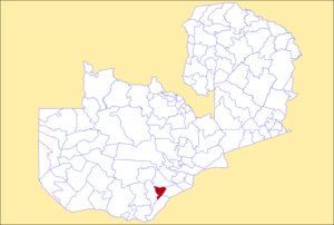
 District location in Zambia District location in Zambia | |
| Country | |
| Province | Southern Province |
| Area | |
| • Total | 1,887.2 km (728.7 sq mi) |
| Population | |
| • Total | 101,021 |
| • Density | 54/km (140/sq mi) |
| Time zone | UTC+2 (CAT) |
Pemba District is a district of Southern Province, Zambia. The district capital is Pemba. It was separated from Choma District in 2012. As of the 2022 Zambian Census, the district had a population of 101,021 people.
References
- "Districts of Zambia". Statoids. Retrieved December 30, 2018.
- "Zambia: Administrative Division". citypopulation. Retrieved December 30, 2018.
- "Zambia : Sata creates Pemba district in Southern Province". 2012-05-16. Retrieved 2022-11-26.
- 2022 Census of Population and Housing - Preliminary Report (PDF)
| Central Province | |
|---|---|
| Copperbelt Province | |
| Eastern Province | |
| Luapula Province | |
| Lusaka Province | |
| Muchinga Province | |
| Northern Province | |
| North-Western Province | |
| Southern Province | |
| Western Province | |
16°40′S 27°23′E / 16.667°S 27.383°E / -16.667; 27.383
This Zambia location article is a stub. You can help Misplaced Pages by expanding it. |