Human settlement in England
| Carleton | |
|---|---|
 The Castle Gardens public house The Castle Gardens public house | |
   | |
| OS grid reference | SD330393 |
| District | |
| Shire county | |
| Region | |
| Country | England |
| Sovereign state | United Kingdom |
| Post town | POULTON-LE-FYLDE |
| Postcode district | FY6 |
| Dialling code | 01253 |
| Police | Lancashire |
| Fire | Lancashire |
| Ambulance | North West |
| UK Parliament | |
| |
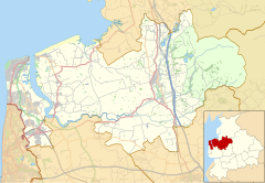
Carleton is a village on the coastal plain of the Fylde in the Borough of Wyre in Lancashire, England. It consists of Great Carleton, Little Carleton, Norcross and Whiteholme and is situated close to Poulton-le-Fylde. Other nearby settlements include Thornton, Bispham and Blackpool. Historically, Carleton was in the parish of Poulton-le-Fylde. It borders the Borough of Blackpool immediately to the west.
History
Carleton was listed in the Domesday Book of 1086 as Carlentun. The name usually means "farmstead or estate of the freemen or peasants", derived from the Old Scandinavian word karl and the Old English word tūn. Its area was estimated in that survey to be four carucates of land and it was owned by Earl Tostig. In the 12th century, Carleton was owned by Gilbert Fitz Reinfred, and in the 13th century, by Emma de St. John.
A free school, Carleton St Hilda's C of E Primary School, was founded in 1604 and is still open today.
Carleton Crematorium and Cemetery opened in 1935.
Governance
Carleton is an electoral ward in the parliamentary constituency of Wyre and Preston North. The population of this ward at the 2011 census was 4,061. Since its creation in 2010, Wyre and Preston North has been represented at Parliament by Conservative MP Ben Wallace.
Following the Constituency Boundary Review 2023, Carleton will sit in the Blackpool North and Fleetwood constituency for the next general election in 2024 or 2025.
In 1866 Carleton became a separate civil parish, on 1 April 1934 the parish was abolished and merged with Blackpool, Poulton le Fylde and Thornton. In 1931 the parish had a population of 1508. It is now in the unparished area of Poulton le Fylde.
Religion
The Anglican church of St Hilda of Whitby and the Roman Catholic church of St Martin de Porres share a site on Fleetwood Road. St Hilda's is part of the ecclesiastical parish of St Chad's Church, Poulton-le-Fylde in the Diocese of Blackburn. St Martin's is in the Roman Catholic Diocese of Lancaster.
See also
References
Footnotes
- "Carleton and Little Carleton, Lancashire, Yorkshire", Domesday Book, The National Archives, 1086, retrieved 7 September 2010
- Mills (1998), p. 71
- Farrer & Brownbill (1912), pp. 228-231
- ^ Porter (1876), p. 280
- Porter (1876), p. 284
- "Ward population 2011". Retrieved 4 June 2015.
- "Relationships and changes Carleton CP/Tn through time". A Vision of Britain through Time. Retrieved 25 March 2024.
- "Population statistics Carleton CP/Tn through time". A Vision of Britain through Time. Retrieved 25 March 2024.
- "Carleton, Lancashire Genealogy", GENUKI, 30 June 2010, retrieved 12 September 2010
- "Church Details: Carleton St Hilda of Whitby", blackburn.anglican.org, Diocese of Blackburn, archived from the original on 28 September 2011, retrieved 31 May 2011
Sources
- Farrer, William; Brownbill, J., eds. (1912), "Townships — Carleton", A History of the County of Lancaster: Volume 7, Constable, OCLC 59626695
- Hartwell, Clare; Pevsner, Nikolaus (2009) . Lancashire: North. New Haven and London: Yale University Press. ISBN 978-0-300-12667-9.
- Mills, A. D. (1998). Dictionary of English Place-Names. Oxford University Press. ISBN 0-19-280074-4.
- Porter, John (1876). History of the Fylde of Lancashire. W. Porter. OCLC 12931605.
- Storey, Christine (2001). Poulton-le-Fylde. Stroud: Tempus Publishing. ISBN 0-7524-2442-4.
External links
 Media related to Carleton, Lancashire at Wikimedia Commons
| Geography of the Borough of Wyre | |||||||
|---|---|---|---|---|---|---|---|
| Towns | |||||||
| Villages |
| ||||||
| Parishes | |||||||
| Topography |
| ||||||