| Mount Graham | |
|---|---|
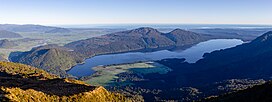
 Lake Kaniere with Mt Graham in the middle Lake Kaniere with Mt Graham in the middle | |
| Highest point | |
| Elevation | 829 m (2,720 ft) |
| Coordinates | 42°50′12″S 171°06′15″E / 42.83664°S 171.10415°E / -42.83664; 171.10415 |
| Naming | |
| Defining authority | New Zealand Geographic Board |
| Geography | |
 | |
| Country | New Zealand |
| Region | West Coast |
| Territorial authority | Westland District |
| Topo map | Land Information New Zealand NZ Topo50, BV19 |
Mount Graham is a mountain in the West Coast Region of New Zealand with an elevation of 829 metres above sea level. Lake Kaniere is immediately east of Mount Graham. It is also a prime spot for hunting Red deer during the breeding season. The mountain is covered in dense bush which makes it hard to reach the summit.
References
- LINZ's 1:50,000 map at the interactive topographic map of New Zealand site
- "Kokatahi-Toaroha hunting". www.doc.govt.nz. Retrieved 28 June 2023.
This West Coast Region (New Zealand) geography article is a stub. You can help Misplaced Pages by expanding it. |