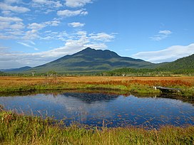
| Mount Hiuchi | |
|---|---|
| Hiuchigatake | |
 | |
| Highest point | |
| Elevation | 2,356 m (7,730 ft) |
| Coordinates | 36°57′7″N 139°17′19″E / 36.95194°N 139.28861°E / 36.95194; 139.28861 |
| Naming | |
| Native name | 燧ヶ岳 (Japanese) |
| Geography | |
  | |
| Geology | |
| Rock age | Quaternary |
| Mountain type | Stratovolcano |
| Last eruption | July 1544 |
Mount Hiuchi, also Hiuchigatake (Japanese: 燧ヶ岳) is a 2,356 m tall stratovolcano in Oze National Park, and located in Hinoemata Village, Minami-Aizu gun, Fukushima Prefecture, Japan. This is the highest mountain in Tōhoku region. The volcano rises in the north of Lake Ozenuma [ja]. It is one of the 100 Famous Japanese Mountains.
Morphology
| This section does not cite any sources. Please help improve this section by adding citations to reliable sources. Unsourced material may be challenged and removed. (December 2017) (Learn how and when to remove this message) |
Hiuchi initially formed around 350,000 years ago. Around 160,000–170,000 years ago, Hiuchi erupted, creating a large pyroclastic flow deposit. At the summit of the volcano lie two lava domes, Akanagure (赤ナグレ) and Mi-ike (御池岳). Akanagure, the southern dome, produced a series of viscous lava flows that flowed down the southern and western parts of the volcano about 3500 years ago. Mi-ike is responsible for the only recorded activity.
Historic eruptions
1544 eruptions
The only recorded activity was on July 28, 1544. A moderate phreatic eruption at the Mi-ike Lava Dome produced lahars and an associated tephra layer.
 Mount HiuchigatakeOzegaharaLake Ozenuma [ja]Mount Shibutsuclass=notpageimage| Around Ozegahara
See also
- Asteroid 6883 Hiuchigatake, named after Hiuchigatake
- List of volcanoes in Japan
- List of mountains in Japan
References
- ^ "Hiuchigatake: National catalogue of the active volcanoes in Japan" (PDF). Japan Meteorological Agency. Retrieved 2017-12-13.
- ^ "燧ヶ岳" (in Japanese). kotobank. Retrieved 2017-12-13.
- "Oze National Park_Guide of Highlights [MOE]".
- "日本百名山" (in Japanese). kotobank. Retrieved 2017-12-13.
- Yukio Hayakawa (1994). "燧ヶ岳で見つかった約500年前の噴火堆積物". 火山 (in Japanese). 39 (5). doi:10.18940/kazan.39.5_243.
Further reading
- Yukio Hayakawa; Fusao Arai; Tomohiro Kitazume (1997). "Eruptive History of Hiuchi Volcano". Journal of Geography (Chigaku Zasshi). 106 (5): 660–664. doi:10.5026/jgeography.106.5_660.
External links
- National catalogue of the active volcanoes in Japan: Hiuchigatake - Japan Meteorological Agency
- Quaternary Volcanoes: Hiuchigatake - Geological Survey of Japan, AIST
- "Hiuchigatake". Global Volcanism Program. Smithsonian Institution. Retrieved 2021-06-24.
- Volcanolive.com
| 100 Famous Japanese Mountains | |||||||||
|---|---|---|---|---|---|---|---|---|---|
| Hokkaidō | |||||||||
| Tōhoku region Jōshinetsu region |
| ||||||||
| Kantō region | |||||||||
| Chūbu region |
| ||||||||
| Western Japan | |||||||||
| |||||||||
This Fukushima Prefecture location article is a stub. You can help Misplaced Pages by expanding it. |
