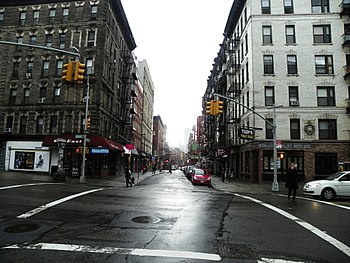
 Mulberry Street in 2012 Mulberry Street in 2012 | |
| North end | Bleecker Street |
|---|---|
| South end | Worth Street |
| East | Mott Street |
| West | Baxter Street |

Mulberry Street is a principal thoroughfare in Lower Manhattan, New York City, United States. It is historically associated with Italian-American culture and history, and in the late 19th and early 20th centuries was the heart of Manhattan's Little Italy.
The street was listed on maps of the area since at least 1755. The "Bend" in Mulberry, where the street changes direction from southeast to northwest to a northerly direction, was made to avoid the wetlands surrounding the Collect Pond. During the period of the American Revolution, Mulberry Street was usually referred to as "Slaughter-house Street", named for the slaughterhouse of Nicholas Bayard on what is now the southwest corner of Mulberry and Bayard Streets, which was located there until the summer of 1784, when it was ordered to be removed to Corlaer's Hook.
Mulberry Bend, formed by Mulberry Street on the east and Orange Street on the west, was historically part of the core of the infamous Five Points; the southwest corner of Mulberry Bend formed part of the Five Points intersection for which the neighborhood was named. Aside from Mulberry, the other four streets forming Five Points were Anthony Street (now Worth Street), Cross Street (now Mosco Street), Orange Street (now Baxter Street), and Little Water Street (which no longer exists).
Location
Mulberry is located between Baxter and Mott Streets. It runs north to south, through the centers of Little Australia and Little Italy, parallel to Mott Street one block to the east, is bound on the north by Bleecker Street in NoHo and on the south by Worth Street in the Civic Center. Near the southern portion of Mulberry Street, the street enters Chinatown, where it is lined with Chinese green grocers, butcher stores, and fishmongers.
Further south past Bayard Street, on the west side of the street, lies Columbus Park, which was created in 1897. The southwest corner of the park (away from Mulberry Street) is the site of the original Five Points intersection. The east side of the street is now lined with Chinatown's funeral homes.
Mulberry Bend

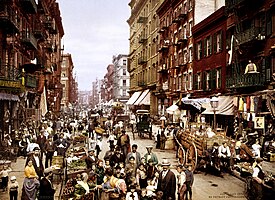
The street was named after the mulberry trees that once lined Mulberry Bend, the slight bend in Mulberry Street. "Mulberry Bend is a narrow bend in Mulberry Street, a tortuous ravine of tall tenement-houses ... so full of people that the throngs going and coming spread off the sidewalk nearly to the middle of the street ... The crowds are in the street because much of the sidewalk and all of the gutter is taken up with vendors' stands."
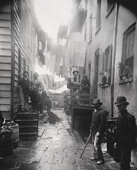
For the urban reformer Jacob Riis, Mulberry Bend epitomized the worst of the city's slums: "A Mulberry Bend Alley" contrasted with "Mulberry Bend becomes a park" were two of the photographs illustrating Jacob Riis's call for renewal in The Battle with the Slum (1902). In response to reformers such as Riis, the city in the 1890s bought out many of the slumlords and replaced tenements with Columbus Park.
Notable buildings
The Puck Building stands near the north end of the street on the southwest corner of Houston Street. Further south is Saint Patrick's Old Cathedral, standing in its churchyard. The Church of the Most Precious Blood, at 113 Baxter Street, was built by Italians, who as new immigrants were not allowed to worship in the main Churches of Transfiguration nor St. Patrick's Old Cathedral. Below Prince Street (no. 247) is the former Ravenite Social Club, where wire taps acquired evidence that sent John Gotti to prison.
The Italian American Museum is at 155 Mulberry and Grand Street in the building that used to house the Italian immigrant bank Banca Stabile.
-
 Black Horse Tavern Mulberry And Park St.
-
 Saint Patrick's Old Cathedral (1815)
-
 St. Philip's Church, Mulberry St.
Culture
Social structure
The New York Times sent its reporters to characterize the Little Italy/Mulberry neighborhood in May 1896:
They are laborers; toilers in all grades of manual work; they are artisans, they are junkman, and here, too, dwell the rag pickers....There is a monster colony of Italians who might be termed the commercial or shop keeping community of the Latins. Here are all sorts of stores, pensions, groceries, fruit emporiums, tailors, shoemakers, wine merchants, importers, musical instrument makers....There are notaries, lawyers, doctors, apothecaries, undertakers.... There are more bankers among the Italians than among any other foreigners except the Germans in the city.
-
 Children sleeping in Mulberry Street (1890)
-
 Produce stand on Mulberry Street
-
 Tai Chi practiced on Mulberry Street
-
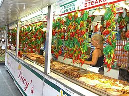
 Feast in Little Italy on Mulberry
Feast of San Gennaro
Main article: Feast of San Gennaro § In the United States
During the Italian-American festival of the Feast of San Gennaro each September, the entire street is blocked off to vehicular traffic for the street fair. The San Gennaro Feast began in 1926 and continues as of 2024. It is the largest Italian-American Festival in New York and possibly the United States.
In popular culture
Manhattan's Mulberry Street has been the subject of books, films, and music. For example:
Books
- The King of Mulberry Street, by Donna Jo Napoli. A young boy in the 1890s travels alone from Napoli (Naples), Italy to New York, where he settles on Mulberry Street.
Music
- Billy Joel's song "Big Man on Mulberry Street" is a jazz-influenced song from his album The Bridge (1986).
- Twenty One Pilots' "Mulberry Street" from their album Scaled and Icy.
See also
References
- Staff (April 1, 1896). "Abattoirs; History of New-York Slaughter-Houses — Interesting and Curious Data" (PDF). The New York Times.
- Herman, Michele "Five Points" in Jackson, Kenneth T., ed. (2010). The Encyclopedia of New York City (2nd ed.). New Haven: Yale University Press. ISBN 978-0-300-11465-2., p.456
- Chin, RK. "A Journey Through Chinatown: Mulberry Street". RK Chin Web Gallery. Retrieved April 16, 2015.
- "Columbus Park". New York City Department of Parks and Recreation. Retrieved October 27, 2007.
- Naureckas, Jim. "Mulberry Street: A New York Songline". New York Songlines. Retrieved April 16, 2015.
- Logan, Harlan (1894). "The Bowery and Bohemia". Scribner's Magazine. p. 458.
- Max Page devotes a section to "Jacob Riis and the 'leprous houses' of Mulberry Bend" in The Creative Destruction of Manhattan, 1900–1940, 2001:73 ff
- Fernando, Nisha (2007). Culture and Identity in Urban Streets: A Case Study of Chinatown, New York City. p. 111. ISBN 9780549437819.
- Mallozzi, Vincent M. (September 8, 2008). "In Little Italy, a Former Bank Will Now Hold Italian Immigrants' Memories". The New York Times.
- Warerkar, Tanay (2018-01-17). "First look at Little Italy's revamped Italian American Museum". Curbed NY. Retrieved 2021-10-23.
- Kaufman, Joanne (2021-10-13). "Bricks Return With Style in New High-End Buildings". The New York Times. ISSN 0362-4331. Retrieved 2021-10-23.
- "Home". Italian American Museum. Retrieved 2021-10-23.
- Staff (May 31, 1896). "Little Italy in New-York". The New York Times. p. 32.
- "Billy Joel, AXS TV, Jazz Fest Release 'Big Man On Mulberry Street' Performance". BillyJoel.com. May 20, 2013.
Further reading
- Frunza, Bogdana Simina (2008). Streetscape and Ethnicity: New York's Mulberry Street and the Redefinition of the Italian American Ethnic Identity.
- Gabaccia, Donna R. (2007). "'Inventing' Little Italy (2006 SHGAPE Presidential Address)". Journal of the Gilded Age and Progressive Era. pp. 7–41. JSTOR 25144462.
- Pozzetta, George E. (1979). Harney, Robert F.; Scarpaci, J. Vincenza (eds.). "The Mulberry District of New York City: The Years before World War One". Little Italies in North America. Toronto: The Multicultural History Society of Ontario. pp. 7–40.
External links
- New York Songlines: Mulberry Street, a virtual walking tour
- Mulberry Street Storefronts - photographs of buildings and stores along Mulberry St from Chinatown through Little Italy
- "Mulberry Street, New York City". World Digital Library. 1900.
| Streets of Manhattan | |||||||||||||||||
|---|---|---|---|---|---|---|---|---|---|---|---|---|---|---|---|---|---|
| North–south |
| ||||||||||||||||
| East–west |
| ||||||||||||||||
| Intersections |
| ||||||||||||||||
| |||||||||||||||||
| Chinatown, Manhattan | |||||||
|---|---|---|---|---|---|---|---|
| Manhattan, New York City | |||||||
| Green spaces | |||||||
| Education | |||||||
| Religion | |||||||
| Culture |
| ||||||
| Other buildings |
| ||||||
| Transportation |
| ||||||
| Related topics | |||||||
| See also: Manhattan Community Board 2, Manhattan Community Board 3 | |||||||
40°43′13″N 73°59′49″W / 40.7202°N 73.9970°W / 40.7202; -73.9970
Categories: