River in New South Wales, Australia
| Oaky River | |
|---|---|
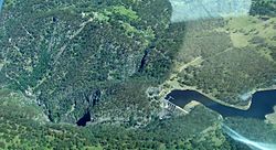
 Oaky River Dam and gorge Oaky River Dam and gorge | |
| Location | |
| Country | Australia |
| State | New South Wales |
| IBRA | New England Tablelands |
| District | Northern Tablelands |
| local government area | Armidale Dumaresq |
| Physical characteristics | |
| Source | Round Mountain, Sonwy Range, Great Dividing Range |
| • location | below Point Lookout, near Ebor |
| • elevation | 1,400 m (4,600 ft) |
| Mouth | confluence with the Chandler River |
| • location | near Jeogla |
| • elevation | 277 m (909 ft) |
| Length | 60 km (37 mi) |
| Basin features | |
| River system | Macleay River catchment |
| Tributaries | |
| • right | Ponds Creek |
| National park | Cathedral Rock NP, New England NP |
Oaky River, a perennial stream of the Macleay River catchment, is located in the Northern Tablelands district of New South Wales, Australia.
Course and features
Oaky River rises on the southern slopes of Round Mountain, the highest peak of the Snowy Range, a spur of the Great Dividing Range south southwest of Ebor, and flows generally southwest, joined by one minor tributary before reaching its confluence with the Chandler River, southwest of Jeogla. The river descends 881 metres (2,890 ft) over its 51 kilometres (32 mi) course; rapidly descending into a deep gorge where it meets the Chandler River.
The upper reaches of Oaky River are transversed by the Waterfall Way between Wollomombi and Ebor.
Oaky River and its tributaries are trout streams and platypus may be sighted in the waters.
Reservoir & Hydroelectric Power Station
The river is impounded by Oaky River Dam, located approximately 40 kilometres (25 mi) from Armidale. At capacity, the dam covers around 42 hectares (100 acres) and holds 2,780 megalitres (98×10^ cu ft) of water. A hydroelectric power station is located at the dam and the flow of water is used to generate electricity. The power station has five turbines that generate 12 megawatts (16,000 hp). Zihni Buzo, an Albanian migrant and Harvard-educated civil engineer was the leading engineer on the construction of the dam and hydroelectric scheme. This dam burst in February 2013 and is no longer viable.
See also
References
- ^ "Map of Oaky River, NSW". Bonzle Digital Atlas of Australia. Retrieved 4 March 2013.
- "Trout and salmon fishing rules: Northern NSW Trout Waters". Fishing and aquaculture. NSW Primary Industries. Archived from the original on 21 August 2009. Retrieved 26 February 2011.
- "About us". Wakefield Charolais. Retrieved 26 February 2011.
- Lindsay, Judy (2019). "Launch of EA Newcastle Division Oral History Collection: How the Collection evolved, and its publication on the UoN SoundCloud" (PDF). Engineering Heritage Australia Magazine. 3 (1): 6–7.
- Special Collections (30 November 2017). "The Dam that Zihni Built". Hunter Living Histories. University of Newcastle. Retrieved 28 January 2022.
- "Diga që ndërtoi Zihni Buzo në Australi" [The Dam built by Zihni Buzo in Australia] (in Albanian). Diaspora Shqiptare. 4 January 2022. Retrieved 28 January 2022.
- "Archived copy" (PDF). Archived from the original (PDF) on 11 March 2019. Retrieved 27 April 2019.
{{cite web}}: CS1 maint: archived copy as title (link)
External links
- "Macleay River catchment" (map). Office of Environment and Heritage. Government of New South Wales.
| River systems and rivers of the Northern Rivers catchments, New South Wales, Australia | |
|---|---|
| Tweed Shire and Tweed River | |
| Byron Shire and Brunswick River | |
| Richmond Valley and Richmond River | |
| Clarence Valley and Clarence River |
|
| Coffs Harbour, Bellingen Shire, and Bellinger River | |
| Nambucca Shire, Kempsey Shire, and Nambucca-Macleay rivers | |
| Port Macquarie-Hastings and Hastings River | |
| New England region of New South Wales, Australia | |
|---|---|
| Federal divisions | |
| State electorates | |
| Local government areas | |
| Cities | |
| Towns and villages |
|
| National parks and other conservation areas |
|
| Rivers |
|
| Mountain ranges and mountains |
|
| Tourist attractions | |
30°40′S 152°01′E / 30.667°S 152.017°E / -30.667; 152.017
Categories: