| Plinkaigalis | |
|---|---|
| Village | |
 | |
  | |
| Coordinates: 55°24′50″N 23°39′40″E / 55.41389°N 23.66111°E / 55.41389; 23.66111 | |
| Country | |
| County | |
| Municipality | Kėdainiai district municipality |
| Eldership | Krakės Eldership |
| Population | |
| • Total | 319 |
| Time zone | UTC+2 (EET) |
| • Summer (DST) | UTC+3 (EEST) |
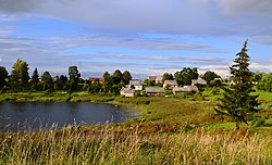
Plinkaigalis (formerly Russian: Плинтагола, Polish: Plintagoła) is a village in Kėdainiai district municipality, in Kaunas County, in central Lithuania. According to the 2011 census, the village had a population of 319 people. It is located 5 kilometres (3.1 mi) from Krakės, along the Krakės-Betygala road, on the right bank of the Šušvė river, on the shore of the Plinkaigalis Lake.
There is the Plinkaigalis hillfort on the confluence of the Šušvė and Žiedupė. Also an ancient burial place with rich grave goods had been found nearby.
History
Plinkaigalis village is known since 1595. In 1632 eleven families lived here and six in 1662. During the 18th century the village once had been deserted but later repopulated as the Krakės manor settlement. During the Soviet era it was a kolkhoz center.
Demography
|
| |||||||||||||||||||||||||||||||||
| Source: 1902, 1923, 1959 & 1970, 1979, 1989, 2001, 2011 | ||||||||||||||||||||||||||||||||||
Images
References
- "Plintagoła". Geographical Dictionary of the Kingdom of Poland (in Polish). 15 pt. 2. Warszawa: Kasa im. Józefa Mianowskiego. 1902. p. 458.
- "2011 census". Statistikos Departamentas (Lithuania). Retrieved August 21, 2017.
- "Plinkaigalis". Tarybų Lietuvos enciklopedija (in Lithuanian). Vol. 3. Vilnius: Vyriausioji enciklopedijų redakcija. 1987. p. 398.
This Kaunas County, Lithuania location article is a stub. You can help Misplaced Pages by expanding it. |


