| Prelesje | |
|---|---|
 | |
 | |
| Coordinates: 46°4′9.44″N 14°11′17.94″E / 46.0692889°N 14.1883167°E / 46.0692889; 14.1883167 | |
| Country | |
| Traditional region | Upper Carniola |
| Statistical region | Upper Carniola |
| Municipality | Gorenja Vas–Poljane |
| Area | |
| • Total | 1.16 km (0.45 sq mi) |
| Elevation | 650.5 m (2,134.2 ft) |
| Population | |
| • Total | 74 |
| • Density | 64/km (170/sq mi) |
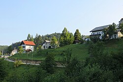
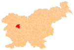
Prelesje (pronounced [pɾɛˈleːsjɛ]) is a small settlement near the village of Lučine in the Municipality of Gorenja Vas–Poljane in the Upper Carniola region of Slovenia.
Name
The name Prelesje is a fused prepositional phrase that has lost case inflection: pre(d) 'before, in front of' + lesje 'woods', referring to its location relative to forested land. Prelesje was attested in older sources as Prilezzi in 1291 and Prilessi in 1500, and the name was transcribed as Perleſsie on the Franciscan land survey of 1818–1828.
Gallery
-
Wayside shrine south of the main part of Prelesje
References
- Statistical Office of the Republic of Slovenia
- Gorenja Vas–Poljane municipal site
- "Prelesje". Slovenska historična topografija. ZRC SAZU Zgodovinski inštitut Milka Kosa. Retrieved August 26, 2020.
- "Franciscejski kataster za območje Slovenije". Register kulturne dediščine. Arhiv Republike Slovenije. Retrieved August 26, 2020.
External links
 Media related to Prelesje at Wikimedia Commons
- Prelesje on Geopedia
This article about the Municipality of Gorenja vas-Poljane in Slovenia is a stub. You can help Misplaced Pages by expanding it. |
