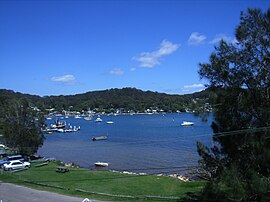
Suburb of Central Coast, New South Wales, Australia
| Pretty Beach Central Coast, New South Wales | |||||||||||||||
|---|---|---|---|---|---|---|---|---|---|---|---|---|---|---|---|
 Araluen Drive, featuring the bay and wharf. Directly opposite is Wagstaffe. Araluen Drive, featuring the bay and wharf. Directly opposite is Wagstaffe. | |||||||||||||||
| Population | 314 (SAL 2021) | ||||||||||||||
| Postcode(s) | 2257 | ||||||||||||||
| Elevation | 2 m (7 ft) | ||||||||||||||
| Location | |||||||||||||||
| LGA(s) | Central Coast Council | ||||||||||||||
| Parish | Kincumber | ||||||||||||||
| State electorate(s) | Terrigal | ||||||||||||||
| Federal division(s) | Robertson | ||||||||||||||
| |||||||||||||||
Pretty Beach is a south-eastern suburb of the Central Coast region of New South Wales, Australia on the Bouddi Peninsula. It is part of the Central Coast Council local government area.
References
- Australian Bureau of Statistics (28 June 2022). "Pretty Beach (Central Coast - NSW) (suburb and locality)". Australian Census 2021 QuickStats. Retrieved 28 June 2022.

- Australian Bureau of Statistics (27 June 2017). "Pretty Beach (Central Coast – NSW)". 2016 Census QuickStats. Retrieved 30 November 2017.

33°31′41″S 151°20′49″E / 33.528°S 151.347°E / -33.528; 151.347
This Central Coast geography article is a stub. You can help Misplaced Pages by expanding it. |